Illorsuit (ö)
| Illorsuit | |
| Ubekendt Ejland | |
| Ö | |
Södra delen av Illorsuit sedd från Ukkusissathalvön. | |
| Land | |
|---|---|
| Koordinater | 71°10′N 53°40′V / 71.167°N 53.667°V |
| Area | 468 km² |
| Befolkning | 99 (2005) |
Illorsuits läge i Grönland | |
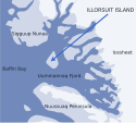
Noggrannare karta | |
Illorsuit (danska: Ubekendt Ejland) är en ö i Uummannaq på Grönland. Dess yta är 468 km2. Den hade 99 invånare år 2005.
Källor
Media som används på denna webbplats
Författare/Upphovsman: Uwe Dedering, Licens: CC BY-SA 3.0
Relief location map of Greenland.
- Projection: EquiDistantConicProjection.
- Area of interest:
- N: 85.0° N
- S: 59.0° N
- W: -75.0° E
- E: -10.0° E
- Projection center:
- NS: 72.0° N
- WE: -42.5° E
- Standard parallels:
- 1: 64.0° N
- 2: 80.0° N
- GMT projection: -JD-42.5/72/64/80/20c
- GMT region: -R-60.16/57.61/24.5/79.91r
- GMT region for grdcut: -R-120.24/57.61/24.5/85.78r
- Relief: SRTM30plus.
- Made with Natural Earth. Free vector and raster map data @ naturalearthdata.com.
Shiny red button/marker widget. Used to mark the location of something such as a tourist attraction.
Författare/Upphovsman: Algkalv (talk), Licens: CC BY-SA 3.0
The southern part of Illorsuit Island, Greenland seen across northeastern Uummannaq Fjord from the western ridge of Nunaarssuaq mountain on Ukkusissat Peninsula.
Författare/Upphovsman: Algkalv (talk), Licens: CC BY-SA 3.0
Location of Illorsuit Island within the Uummannaq Fjord area, Greenland. Sketch map.


