Igaliku

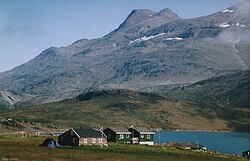
Igaliku är en by i området Södra Grönland ungefär 34 km nordost om Narsaq, grundad 1782. Byn har cirka 40 invånare.
På orten finns ruinerna efter det medeltida biskopssätet Garðar.
Igaliku ingår i området "Kujataa Greenland: Norse and Inuit Farming at the Edge of the Ice Cap" som upptogs på Unescos världsarvslista år 2017.[1]
Källor
- ^ ”Kujataa Greenland: Norse and Inuit Farming at the Edge of the Ice Cap” (på engelska). UNESCO. https://whc.unesco.org/en/list/1536/. Läst 17 mars 2020.
Media som används på denna webbplats
Shiny red button/marker widget. Used to mark the location of something such as a tourist attraction.
Författare/Upphovsman: Uwe Dedering, Licens: CC BY-SA 3.0
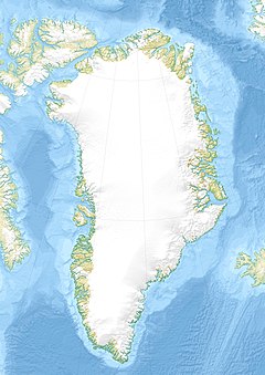
Relief location map of Greenland.
- Projection: EquiDistantConicProjection.
- Area of interest:
- N: 85.0° N
- S: 59.0° N
- W: -75.0° E
- E: -10.0° E
- Projection center:
- NS: 72.0° N
- WE: -42.5° E
- Standard parallels:
- 1: 64.0° N
- 2: 80.0° N
- GMT projection: -JD-42.5/72/64/80/20c
- GMT region: -R-60.16/57.61/24.5/79.91r
- GMT region for grdcut: -R-120.24/57.61/24.5/85.78r
- Relief: SRTM30plus.
- Made with Natural Earth. Free vector and raster map data @ naturalearthdata.com.
Författare/Upphovsman: Serge Kräutle, Licens: CC BY 3.0
Der Berg Illerfissalik, gesehen von Igaliku


