Ichinomiya
| Ichinomiya (一宮市) | |
| Stad | |
| Land | |
|---|---|
| Region | Chubu |
| Prefektur | Aichi |
| Koordinater | 35°21′N 136°46′Ö / 35.350°N 136.767°Ö |
| Area | 113,91 km²[1] |
| Folkmängd | 379 081 (1 oktober 2012)[1] |
| Befolkningstäthet | 3 328 invånare/km² |
| Borgmästare | Masayasu Nakano (2015–) |
| Geonames | 1861949 1861940 |
| Träd | Cornus florida[2] |
| Blomma | Praktklocka[2] |
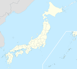
Ichinomiyas läge i Japan | |
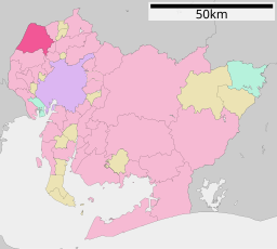
Ichinomiyas läge i Aichi prefektur | |
| Webbplats: Ichinomiyas officiella webbplats | |
Ichinomiya (一宮市, Ichinomiya-shi) är en japansk stad i prefekturen Aichi på den centrala delen av ön Honshu. Den har cirka 380 000 invånare och fick stadsrättigheter 1 september 1921.[1] och har sedan 2002[3] status som speciell stad(japanska: 特例市?, Tokureishi) enligt lagen om lokalt självstyre.[4]
Staden är belägen vid Kisofloden och ligger nordväst om Nagoya, och ingår i denna stads storstadsområde.[5]
Källor
- ^ [a b c] Masahiro Higashide Japansk sida med statistik över areal och folkmängd. Läst 16 mars 2013.
- ^ [a b] läs online, www.city.ichinomiya.aichi.jp.[källa från Wikidata]
- ^ ”施行時特例市一覧” (på japanska). Masahiro Higashide. http://uub.jp/cpf/tokurei.html. Läst 28 augusti 2016.
- ^ ”Revised Local Autonomy Law” (på engelska). Japan Center for Local Autonomy. Mars 2000. http://nippon.zaidan.info/seikabutsu/1999/00168/mokuji.htm. Läst 21 augusti 2016.
- ^ Publikation 2005 Population Census of Japan, Overview Series No.9; Population of Major Metropolitan Areas, Statistics Bureau, Ministry of Internal Affairs and Communications, Japan; ISBN 978-4-8223-3577-9.
Media som används på denna webbplats
Författare/Upphovsman: Maximilian Dörrbecker (Chumwa), Licens: CC BY-SA 3.0
Location map of Japan
Equirectangular projection.
Geographic limits to locate objects in the main map with the main islands:
- N: 45°51'37" N (45.86°N)
- S: 30°01'13" N (30.02°N)
- W: 128°14'24" E (128.24°E)
- E: 149°16'13" E (149.27°E)
Geographic limits to locate objects in the side map with the Ryukyu Islands:
- N: 39°32'25" N (39.54°N)
- S: 23°42'36" N (23.71°N)
- W: 110°25'49" E (110.43°E)
- E: 131°26'25" E (131.44°E)
Shiny red button/marker widget. Used to mark the location of something such as a tourist attraction.
Författare/Upphovsman: ja: 利用者:Lincun, Licens: CC BY-SA 3.0
Location of Ichinomiya in Aichi Prefecture


