Hoxie, Kansas
| Hoxie | |
| city | |
| Land | |
|---|---|
| Delstat | Kansas |
| County | Sheridan County |
| Höjdläge | 827 m ö.h. |
| Koordinater | 39°21′27″N 100°26′31″V / 39.35750°N 100.44194°V |
| Yta | 2,2 km² (2010) |
| - land | 2,2 km² |
| - vatten | 0,0 km² |
| Folkmängd | 1 211 (2020)[1] |
| Befolkningstäthet | 550 invånare/km² |
| Tidszon | CST (UTC-6) |
| - sommartid | CDT (UTC-5) |
| ZIP-kod | 67740 |
| Riktnummer | 785 |
| FIPS | 2033350 |
| Geonames | 5445627 |
Ortens läge i Kansas | |
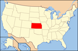
Kansas läge i USA | |
Hoxie är administrativ huvudort i Sheridan County i Kansas.[2][3] Orten har fått sitt namn efter järnvägsfunktionären H.M. Hoxie.[4] Enligt 2020 års folkräkning hade Hoxie 1 211 invånare.[1]
Källor
- ^ [a b] ”Hoxie city, Kansas 2020 Decennial Census” (på engelska). United States Census Bureau. https://data.census.gov/profile/Hoxie_city,_Kansas?g=1600000US2033350. Läst 16 februari 2023.
- ^ Kansas County Map with County Seat Cities. Geology.com Geoscience News and Information. Läst 16 maj 2017.
- ^ Hoxie, KS. Map Quest. Läst 16 maj 2017.
- ^ Profile for Hoxie, Kansas Arkiverad 19 juni 2017 hämtat från the Wayback Machine.. ePodunk. Läst 16 maj 2017.
|
Media som används på denna webbplats
Shiny red button/marker widget. Used to mark the location of something such as a tourist attraction.
Författare/Upphovsman: This version: uploader
Base versions this one is derived from: originally created by en:User:Wapcaplet, Licens: CC BY 2.0
Map of USA with Kansas highlighted
Författare/Upphovsman: Alexrk2, Licens: CC BY 3.0
Den här Det karta skapades med GeoTools.


