Hot Springs, South Dakota
| Hot Springs | |
| city | |
Välkomstskylt | |
| Land | |
|---|---|
| Delstat | South Dakota |
| County | Fall River County |
| Höjdläge | 1 051 m ö.h. |
| Koordinater | 43°25′54″N 103°28′27″V / 43.43167°N 103.47417°V |
| Yta | 9,35 km² (2010) |
| - land | 9,35 km² |
| - vatten | 0,0 km² |
| Folkmängd | 3 711 (2010) |
| Befolkningstäthet | 397 invånare/km² |
| Tidszon | MST (UTC-7) |
| - sommartid | MDT (UTC-6) |
| ZIP-kod | 57747 |
| FIPS | 4630220 |
| Geonames | 5765751 |
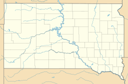
Ortens läge i South Dakota | |
South Dakotas läge i USA | |
| Webbplats: http://www.hs-sd.org/ | |
Hot Springs är administrativ huvudort i Fall River County i South Dakota.[1][2] År 1888 utsågs orten till huvudort i countyt och två år senare förrättades det första borgmästarvalet som vanns av J.B. Dickover.[3]
Kända personer från Hot Springs
- Leslie Jensen, politiker
Källor
- ^ South Dakota County Map with County Seat Cities. Geology.com Geoscience News and Information. Läst 27 maj 2016.
- ^ Profile for Hot Springs, South Dakota Arkiverad 4 augusti 2016 hämtat från the Wayback Machine.. ePodunk. Läst 27 maj 2016.
- ^ History Arkiverad 4 juni 2016 hämtat från the Wayback Machine.. City of Hot Springs, South Dakota. Läst 27 maj 2016.
|
Media som används på denna webbplats
Shiny red button/marker widget. Used to mark the location of something such as a tourist attraction.
Författare/Upphovsman: Huebi, Licens: CC BY 2.0
Map of USA with South Dakota highlighted
Författare/Upphovsman: Runner1928, Licens: CC BY-SA 4.0
Welcome to Hot Springs, South Dakota
Författare/Upphovsman: Alexrk, Licens: CC BY 3.0
Location map of South Dakota, USA


