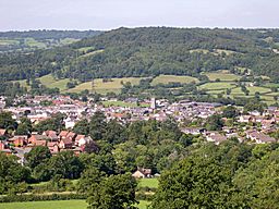
Honiton
| Honiton | |
| Stad | |
(c) Tony Atkin, CC BY-SA 2.0 Vy över Honiton | |
| Land | |
|---|---|
| Riksdel | England |
| Region | Sydvästra England |
| Ceremoniellt grevskap | Devon |
| Administrativt grevskap | Devon |
| Distrikt | East Devon |
| Koordinater | 50°47′53″N 03°11′33″V / 50.79806°N 3.19250°V |
| Area | 3,21 km²[1] |
| Folkmängd | 11 483 (2011)[1] |
| Befolkningstäthet | 3 577 invånare/km² |
| Tidszon | WET (UTC+0) |
| - sommartid | BST (UTC+1) |
| Postort | HONITON |
| Postnummer | EX14 |
| Riktnummer | 01404 |
| Geonames | 2646658 7298183 |
Contains Ordnance Survey data © Crown copyright and database right, CC BY-SA 3.0 Honitons läge i Devon | |
| Webbplats: www.honiton.gov.uk | |
Honiton är en stad och civil parish i grevskapet Devon i England. Staden ligger i distriktet East Devon och ligger vid floden Otter, cirka 25 kilometer nordost om Exeter. Tätorten (built-up area) hade 11 483 invånare vid folkräkningen år 2011.[1]
Referenser
- ^ [a b c] ”Honiton Built-up area - Local Area Report - Nomis”. www.nomisweb.co.uk. https://www.nomisweb.co.uk/reports/localarea?compare=E34002446. Läst 27 december 2020.
Externa länkar
 Wikimedia Commons har media som rör Honiton.
- Officiell webbplats
Media som används på denna webbplats
Shiny red button/marker widget. Used to mark the location of something such as a tourist attraction.
Contains Ordnance Survey data © Crown copyright and database right, CC BY-SA 3.0
Map of Devon, UK with the following information shown:
- Administrative borders
- Coastline, lakes and rivers
- Motorways and primary routes
- Urban areas
Equirectangular map projection on WGS 84 datum, with N/S stretched 150%
Geographic limits:
- West: 4.72W
- East: 2.86W
- North: 51.3N
- South: 50.16N


