Hjørundfjords kommun
| Hjørundfjords kommun | |
| Hjørundfjord kommune | |
| Tidigare kommun | |
Sæbø | |
| Land | |
|---|---|
| Fylke | Møre og Romsdal fylke |
| Koordinater | 62°12′33″N 6°28′11″Ö / 62.20917°N 6.46972°Ö |
| Centralort | Sæbø |
| Area | 277 km² |
| Grundad | 1 januari 1838 |
| Upphört | 31 december 1963[1] |
| - Uppgått i | Ørsta kommun[1] |
| - Nuvarande kommun | Ørsta kommun |
| Kommunkod | 1522 |
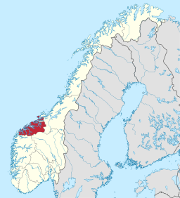
 Hjørundfjords kommun i Møre og Romsdal fylke. | |
(c) Karte: NordNordWest, Lizenz: Creative Commons by-sa-3.0 de Møre og Romsdal fylke i Norge. | |
| Wikimedia Commons: Hjørundfjorden | |
| Redigera Wikidata | |
Hjørundfjords kommun (norska: Hjørundfjord kommune) var en kommun i Møre og Romsdal fylke i västra Norge. Kommunen omfattade den östra delen av nuvarande Ørsta kommun och gränsade till Sogn og Fjordane fylke i söder. Byn Sæbø utgjorde kommunens centralort.
Administrativ historik
Hjørundfjords kommun upprättades den 1 januari 1838 (som Jørringfjord formannskapsdistrikt) när Formannskapslovene från 1837 trädde i kraft.
Den 1 januari 1964 gick Hjørundfjords kommun, tillsammans med Vartdals kommun, upp i Ørsta kommun. Kommunens hade då 1 728 invånare.[2]
Källor
- ^ [a b] Dag Juvkam, Historisk oversikt over endringer i kommune- og fylkesinndelingen, Statistisk sentralbyrå, maj 1999, s. 60, ISBN 82-537-4684-9, läs online.[källa från Wikidata]
- ^ ”Historisk oversikt over endringer i kommune- og fylkesinndelingen” (PDF). Statistisk sentralbyrå. Maj 1999. https://www.ssb.no/a/publikasjoner/pdf/rapp_9913/rapp_9913.pdf.
| ||||||||||
Media som används på denna webbplats
Författare/Upphovsman: Gutten på Hemsen, Licens: CC0
Flag of Norway with colors from the previous version on Commons. This file is used to discuss the colors of the Norwegian flag.
(c) Karte: NordNordWest, Lizenz: Creative Commons by-sa-3.0 de
Location of county Møre og Romsdal in Norway (2024)
Møre & Romsdal's county coat of arms. Shows three yellow Viking ships seen from the front on a blue background.
Hjørundfjord kyrkje på Sæbø ved Hjørundfjorden i Ørsta)
Författare/Upphovsman: Jay1279, Licens: CC0
Map of Hjørundfjord municipality in Møre og Romsdal county, Norway (1838-1963)


