Hildenborough
| Hildenborough | |
| Ort | |
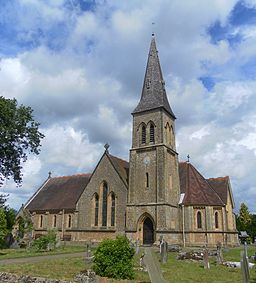
St John the Evangelist's Church i Hildenborough | |
| Land | |
|---|---|
| Riksdel | England |
| Region | Sydöstra England |
| Ceremoniellt grevskap | Kent |
| Administrativt grevskap | Kent |
| Distrikt | Tonbridge and Malling |
| Koordinater | 51°12′54″N 0°14′45″Ö / 51.21500°N 0.24583°Ö |
| Area | 2,40 km² (2021)[1] |
| Folkmängd | 4 944 (2021)[2][3] |
| Befolkningstäthet | 2 060 invånare/km² |
| Tidszon | WET (UTC+0) |
| - sommartid | BST (UTC+1) |
| Postort | TONBRIDGE |
| Postnummer | TN11 |
| Riktnummer | 01732 |
| Geonames | 2646906 7295912 |
Contains Ordnance Survey data © Crown copyright and database right, CC BY-SA 3.0 Hildenboroughs läge i Kent | |
| Webbplats: www.hildenboroughpc.org.uk | |
Hildenborough är en ort och civil parish i grevskapet Kent i sydöstra England. Orten ligger i distriktet Tonbridge and Malling, strax nordväst om Tonbridge. Tätorten (built-up area) hade 4 944 invånare vid folkräkningen år 2021.[2][3]
Referenser
- ^ ”Built Up Areas (2022) GB BGG” (på engelska). geoportal.statistics.gov.uk. Office for National Statistics (ONS). https://geoportal.statistics.gov.uk/datasets/ons::built-up-areas-2022-gb-bgg/about. Läst 9 september 2023.
- ^ [a b] ”Output Area (2021) to Built Up Area to Local Authority District to Region (December 2022) Lookup in England and Wales” (på engelska). geoportal.statistics.gov.uk. Office for National Statistics (ONS). https://geoportal.statistics.gov.uk/datasets/58e34e32a0194f1597d477f5ba93961b_0/about. Läst 9 september 2023.
- ^ [a b] ”Topic Summaries” (på engelska). www.nomisweb.co.uk. Office for National Statistics (ONS). https://www.nomisweb.co.uk/sources/census_2021_ts. Läst 9 september 2023.
Externa länkar
 Wikimedia Commons har media som rör Hildenborough.
Media som används på denna webbplats
Contains Ordnance Survey data © Crown copyright and database right, CC BY-SA 3.0
Map of Kent, UK with the following information shown:
- Administrative borders
- Coastline, lakes and rivers
- Roads and railways
- Urban areas
Equirectangular map projection on WGS 84 datum, with N/S stretched 160%
Geographic limits:
- West: 0.01E
- East: 1.47E
- North: 51.52N
- South: 50.88N
Shiny red button/marker widget. Used to mark the location of something such as a tourist attraction.
Författare/Upphovsman: The Voice of Hassocks, Licens: CC0
St John the Evangelist parish church, London Road, Hildenborough, Kent, England. Built in the 19th century for Hildenborough village, which was then in the large parish of Tonbridge. It is now separately parished.


