Hereford
| Hereford | ||
| Stad | ||
Katedralen i Hereford | ||
| ||
| Land | ||
|---|---|---|
| Riksdel | England | |
| Region | West Midlands | |
| Enhetskommun | Herefordshire | |
| Ceremoniellt grevskap | Herefordshire | |
| Koordinater | 52°03′19″N 02°42′55″V / 52.05528°N 2.71528°V | |
| Area | 17,05 km²[1] | |
| Folkmängd | 60 415 (2011)[1] | |
| Befolkningstäthet | 3 543 invånare/km² | |
| Tidszon | WET (UTC+0) | |
| - sommartid | BST (UTC+1) | |
| Postort | HEREFORD | |
| Postnummer | HR1, HR2, HR4 | |
| Riktnummer | 01432 | |
| Geonames | 2647074 | |
Contains Ordnance Survey data © Crown copyright and database right, CC BY-SA 3.0 Herefords läge i Herefordshire | ||
| Webbplats: www.herefordcitycouncil.gov.uk | ||
Hereford (engelskt uttal: [ˈhɛrɪfərd]lyssna ) är en stad och civil parish i Herefordshire i England. Staden är huvudort för enhetskommunen Herefordshire och ligger vid floden Wye, cirka 39 kilometer nordväst om Gloucester samt cirka 37 kilometer sydväst om Worcester. Tätorten (built-up area) hade 60 415 invånare vid folkräkningen år 2011.[1]
Staden är centrum för ett handels- och jordbruksområde strax öster om gränsen till Wales. Ursprunget för den vanliga nötkreatursrasen Hereford är i staden. Hereford har också en katedral från 1100-talet.
Special Air Service 22:a regemente hade sitt högkvarter här till slutet av 1990-talet. Stadens fotbollslag heter Hereford United FC.
Referenser
- ^ [a b c] ”Hereford Built-up area - Local Area Report - Nomis”. www.nomisweb.co.uk. https://www.nomisweb.co.uk/reports/localarea?compare=E34004334. Läst 27 december 2020.
Externa länkar
 Wikimedia Commons har media som rör Hereford.
Media som används på denna webbplats
Shiny red button/marker widget. Used to mark the location of something such as a tourist attraction.
Författare/Upphovsman: Diliff, Licens: CC BY-SA 3.0
Hereford Cathedral as viewed from the north-west in Herefordshire, England.
Pronunciation of "Hereford" in British English (Received Pronunciation/South East England)
(c) Ruth Harris, CC BY-SA 2.0
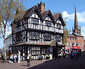
The Old House, High Town, Hereford. Originally part of Butchers Row, and now a museum, this tudor building stands in the middle of Hereford. St Peters church is to the right, and Commercial street leads off to the left.
Contains Ordnance Survey data © Crown copyright and database right, CC BY-SA 3.0
Map of Herefordshire, UK with the following information shown:
- Administrative borders
- Coastline, lakes and rivers
- Roads and railways
- Urban areas
Equirectangular map projection on WGS 84 datum, with N/S stretched 160%
Geographic limits:
- West: 3.15W
- East: 2.33W
- North: 52.45N
- South: 51.80N
Författare/Upphovsman: Rs-nourse, Licens: CC BY-SA 4.0
"The ancient coat of arms of the City of Hereford were Gules, three lions passant guardant in pale argent. But, after the brave and successful defence of the City against the Scots and the Earl of Leven, Charles I. granted an honourable augmentation of the arms, dated 16 Sept. 1645 - Gules, three lions passant guardant in pale argent, on a bordure azure ten saltires of the 2nd." (Strong)
- Strong, George (1848) The Heraldry of Herefordshire: Being a Collection of the Armorial Bearings of Families Which Have Been Seated in the County at Various Periods Down to the Present Time., London: Churton Press


