Hendaye
| Hendaye | ||
| Kommun | ||
 | ||
| ||
| Land | ||
|---|---|---|
| Region | Nouvelle-Aquitaine | |
| Departement | ||
| Arrondissement | Bayonne | |
| Kanton | Hendaye | |
| Koordinater | 43°21′N 1°47′V / 43.350°N 1.783°V | |
| Yta | 7,95 km²[1] | |
| Folkmängd | 18 074 ()[2] | |
| Befolkningstäthet | 2 273 invånare/km² | |
| Tidszon | CET (UTC+1) | |
| - sommartid | CEST (UTC+2) | |
| Postnummer | 64700 | |
| INSEE | 64260 | |
| Geonames | 3013534 | |
| OSM-karta | 166738 | |
 Kommunens läge i regionen Nouvelle-Aquitaine i Frankrike | ||
| Webbplats: https://www.hendaye.fr | ||

Hendaye (baskiska Hendaia) är en kommun i departementet Pyrénées-Atlantiques i regionen Nouvelle-Aquitaine i sydvästra Frankrike. Kommunen ligger i kantonen Hendaye som tillhör arrondissementet Bayonne. Hendaye ligger i det sydvästra hörnet av den historiska provinsen Labourd (Lapurdi) och har broförbindelser med Irun i Gipuzkoa på den spanska sidan av gränsen. År 2022 hade Hendaye 18 074 invånare.
Befolkningsutveckling
Antalet invånare i kommunen Hendaye
 Referens: INSEE[3] |
Galleri
 Hendaye sett från Irun
Se även
Källor
- ^ Répertoire géographique des communes, Institut national de l'information géographique et forestière, läst: 26 oktober 2015.[källa från Wikidata]
- ^ Populations légales 2022, Institut National de la Statistique et des Études Économiques, 19 december 2024.[källa från Wikidata]
- ^ Chiffres clés - Évolution et structure de la population hämtat från the Wayback Machine (arkiverat 4 maj 2012).
Externa länkar
 Wikimedia Commons har media som rör Hendaye.
Media som används på denna webbplats

Författare/Upphovsman: Eric Gaba (Sting - fr:Sting), Licens: CC BY-SA 4.0
Blank physical map of metropolitan France for geo-location purpose.
Scale : 1:14 816 000 (accuracy : about 3,7 km) for the bathymetry. More maps of France, view → Commons Atlas of France.

Shiny red button/marker widget. Used to mark the location of something such as a tourist attraction.

Författare/Upphovsman:
| This illustration was made by Peter Potrowl.
Please credit this with : © Peter Potrowl in the immediate vicinity of the image. A link to my website sitemai.eu would be much appreciated but isn't mandatory. An email to
Do not copy this image illegally by ignoring the terms of the license below, as it is not in the public domain.
If you would like special permission to use, license, or purchase the image please contact me More free pictures in my website. Donations are accepted here and here. |
Coat of arms of Hendaye (Pyrénées-Atlantiques, France)

Författare/Upphovsman: https://www.flickr.com/photos/mikelo/, Licens: CC BY-SA 2.0
Hendaye (Northern Basque Country, France), watching from Jaizkibel mountain (Basque Autonomous Community, Spain).

Olndarraitz beach, Hendaia, Labourd
Författare/Upphovsman: Ingen maskinläsbar skapare angavs. Harrieta171 antaget (baserat på upphovsrättsanspråk)., Licens: CC BY 2.5
Hendaye, le port de plaisance. Photo prise le 06/01/07 par Harrieta171

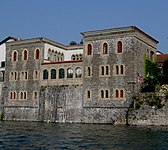
La Villa Mauresque sur la Bidassoa
Författare/Upphovsman:
|
Map data (c) OpenStreetMap contributors, CC-BY-SA _French_municipality_map.svg) • Shape files infrastructure: railway, highways, water: all originally by OpenStreetMap contributors. Status december 2011 *note: shown commune boundaries are from OSM dump May 2012; at that time about 90% complete |
Map commune FR insee code 64260.png

(c) I, Peter Potrowl, CC BY 3.0
Coat of arms of the French departement Pyrénées-Atlantiques (64)
Författare/Upphovsman: Michiel1972, Licens: CC BY-SA 3.0
Population - Municipality code 64260.svg
Population Census 1962-2008