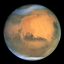
Hellas Planitia
| Marskrater | |
|---|---|
| Hellas Planitia | |
 Hellas Planitia fotograferad av Vikingprogrammet | |
| Egenskaper | |
| Koordinater | 42.43˚ S, 70.50˚ Ö |
| Medeldiameter | 2299.16 km |
| Djup | 7.1 km |
| Mars - ( ) | |
Hitta fler artiklar om Astronomi med Astronomiportalen | |
Hellas Planitia är en nedslagskrater som ligger söder om Mars ekvator. Hellas är den tredje eller fjärde största nedslagskratern och den största synliga nedslagskratern i hela solsystemet. Kratern är 7 152 m djup och 2 300 kilometer lång i diameter från öst till väst. [1] Kratern påstås att ha skapats under den sena tunga bombardemanget när en stor asteroid kolliderade med planeten för ungefär 3,9 miljarder år sedan.[2]
Referenser
- ^ ”Planetary Names: Planitia, planitiae: Hellas Planitia on Mars”. planetarynames.wr.usgs.gov. https://planetarynames.wr.usgs.gov/Feature/2432. Läst 18 december 2016.
- ^ ”Hellas Planitia”. www.daviddarling.info. http://www.daviddarling.info/encyclopedia/H/Hellas_Planitia.html. Läst 18 december 2016.
- Den här artikeln är helt eller delvis baserad på material från engelskspråkiga Wikipedia, Hellas Planitia, 12 december 2016.
| ||||||||||||||||||||||||||||||||||||||||||||||||||||||||
Media som används på denna webbplats
Författare/Upphovsman: Rursus, Licens: CC BY-SA 3.0
Replacement for faulty
 (note the ring "around" Saturn!)
 NASA's Hubble Space Telescope took the picture of Mars on June 26, 2001, when Mars was approximately 68 million kilometers (43 million miles) from Earth — the closest Mars has ever been to Earth since 1988. Hubble can see details as small as 16 kilometers (10 miles) across. The colors have been carefully balanced to give a realistic view of Mars' hues as they might appear through a telescope. Especially striking is the large amount of seasonal dust storm activity seen in this image. One large storm system is churning high above the northern polar cap (top of image), and a smaller dust storm cloud can be seen nearby. Another large dust storm is spilling out of the giant Hellas impact basin in the Southern Hemisphere (lower right).
A colour view of the Hellas Planitia region on Mars created from images taken by the Viking orbiters.


