Heathfield, East Sussex
| Heathfield | |
| Stad | |
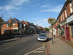
(c) Oast House Archive, CC BY-SA 2.0 High Street i Heathfield | |
| Land | |
|---|---|
| Riksdel | England |
| Region | Sydöstra England |
| Ceremoniellt grevskap | East Sussex |
| Administrativt grevskap | East Sussex |
| Distrikt | Wealden |
| Civil parish | Heathfield and Waldron |
| Koordinater | 50°58′18″N 0°15′6″Ö / 50.97167°N 0.25167°Ö |
| Area | 2,60 km² (2021)[1] |
| Folkmängd | 7 667 (2021)[2][3] |
| Befolkningstäthet | 2 949 invånare/km² |
| Tidszon | WET (UTC+0) |
| - sommartid | BST (UTC+1) |
| Postort | HEATHFIELD |
| Postnummer | TN21 |
| Riktnummer | 01435 |
| Geonames | 2647218 |
Contains Ordnance Survey data © Crown copyright and database right, CC BY-SA 3.0 Heathfields läge i East Sussex | |
Heathfield är en småstad i grevskapet East Sussex i sydöstra England. Staden ligger i distriktet Wealden, mellan Eastbourne och Royal Tunbridge Wells. Tätorten (built-up area) hade 7 667 invånare vid folkräkningen år 2021.[2][3]
Heathfield var en civil parish fram till 1990 när blev den en del av civil parishen Heathfield and Waldron.[4] Civil parishen hade 3 244 invånare år 1961.[5]
Referenser
- ^ ”Built Up Areas (2022) GB BGG” (på engelska). geoportal.statistics.gov.uk. Office for National Statistics (ONS). https://geoportal.statistics.gov.uk/datasets/ons::built-up-areas-2022-gb-bgg/about. Läst 9 september 2023.
- ^ [a b] ”Output Area (2021) to Built Up Area to Local Authority District to Region (December 2022) Lookup in England and Wales” (på engelska). geoportal.statistics.gov.uk. Office for National Statistics (ONS). https://geoportal.statistics.gov.uk/datasets/58e34e32a0194f1597d477f5ba93961b_0/about. Läst 9 september 2023.
- ^ [a b] ”Topic Summaries” (på engelska). www.nomisweb.co.uk. Office for National Statistics (ONS). https://www.nomisweb.co.uk/sources/census_2021_ts. Läst 9 september 2023.
- ^ ”The Wealden (Parishes) Order 1990”. Local Government Boundary Commission for England. Arkiverad från originalet den 3 februari 2023. https://web.archive.org/web/20230203194228/https://s3-eu-west-2.amazonaws.com/lgbce/__data/assets/pdf_file/0005/12767/wealden-parishes-order-1990.pdf. Läst 4 februari 2023.
- ^ ”Population statistics Heathfield CP/AP through time”. A Vision of Britain through Time. https://visionofbritain.org.uk/unit/10296249/cube/TOT_POP. Läst 4 februari 2023.
Externa länkar
 Wikimedia Commons har media som rör Heathfield.
Media som används på denna webbplats
Shiny red button/marker widget. Used to mark the location of something such as a tourist attraction.
Contains Ordnance Survey data © Crown copyright and database right, CC BY-SA 3.0
Map of East Sussex, East Sussex, UK, with the following information shown:
- Administrative borders
- Coastline, lakes and rivers
- Roads and railways
- Urban areas
Equirectangular map projection on WGS 84 datum, with N/S stretched 155%
Geographic limits:
- West: 0.28W
- East: 0.91E
- North: 51.2N
- South: 50.7N
(c) Oast House Archive, CC BY-SA 2.0
High Street, Heathfield, East Sussex


