Heard- och McDonaldöarna
| Heard- och McDonaldöarna | |
 | |
| Geografiskt läge | |
|---|---|
| Koordinater | 53°6′0″S 74°31′0″Ö / 53.10000°S 74.51667°Ö |
| Land | |
| Region* | Asien |
| Data | |
| Typ | Naturarv |
| Kriterier | VIII, IX |
| Referens | 577 |
| Historik | |
| Världsarv sedan | 1997 (21:e mötet) |
| * Enligt Unescos indelning. | |


Heard- och McDonaldöarna, Heard and McDonald Islands, är en obebodd australisk ögrupp i södra Indiska oceanen. Ögruppen består av Heardön, Heard Island, 368 km², McDonald Island, 1 km², samt några mindre öar. Den upptäcktes av amerikanen John Heard 1853.[1] Ögruppen har tillhört Australien sedan 1947 och här finns landets enda två aktiva vulkaner, av vilken den ena, Mawson Peak, är Australiens högsta berg. Mawson Peak är en del av Big Ben-massivet på Heardön och den andra vulkanen finns på McDonald Island. När den fick ett utbrott 1992 var det efter 75 000 år utan aktivitet. Det senaste utbrottet skedde den 10 augusti 2005.
På Heardön finns ett stort antal glaciärer. De täcker ca 70 % av öns yta.[2] Glaciärernas storlek har minskat markant sedan 1940-talet. Till de större glaciärerna hör de åtta glaciärerna Baudissin Glacier, Vahsel Glacier, Abbotsmith Glacier, Challenger Glacier, Gotley Glacier, Brown Glacier, Schmidt Glacier och Compton Glacier.
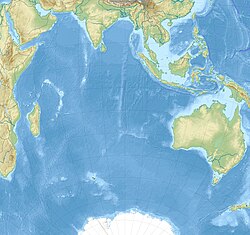
Öarna skrevs 1997 in på Unescos världsarvslista. De tillhör några av jordens mest avlägsna platser. De är belägna cirka 4 099 km sydväst om Perth[3], 3 845 km sydväst om Cape Leeuwin, 4 200 km sydost om Sydafrika, 3 830 km sydost om Madagaskar, 1 630 km norr om Antarktis och 450 km sydost om Kerguelen.[4] Öarna är för närvarande obebodda.
En amerikansk seglare, kapten John Heard, på skeppet Oriental, siktade Heard Island den 25 november 1853, på sin seglats från Boston till Melbourne. Han anmälde upptäckten en månad senare och fick ön namngiven efter sig. Kaptenen William McDonald ombord på Samarang upptäckte den närliggande McDonald Island sex veckor senare, den 4 januari 1854.
Den 3 april 2025 införde USAs president Donald Trump importtullar från Heard- och McDonaldöarna. Importtullarna sattes till 10% och gäller alla australiska externa territorier utom Norfolkön (29 procent).[5]
Noter
- ^ Carlquist, Gunnar (red.) (1932). Svensk uppslagsbok. Malmö: Svensk Uppslagsbok AB:s förlag, band 12 s. 836.
- ^ ”Glaciology”. Australian Antarctic Division,. http://heardisland.antarctica.gov.au/nature/landforms/glaciology. Läst 16 januari 2017.
- ^ Perth
- ^ Distans
- ^ Lyons, Kate; Evershed, Nick (3 april 2025). ”‘Nowhere on Earth is safe’: Trump imposes tariffs on uninhabited islands near Antarctica” (på brittisk engelska). The Guardian. ISSN 0261-3077. https://www.theguardian.com/us-news/2025/apr/03/donald-trump-tariffs-antarctica-uninhabited-heard-mcdonald-islands. Läst 4 april 2025.
Externa länkar
 Wikimedia Commons har media som rör Heard- och McDonaldöarna.
- UNESCO World Heritage Centre - Heard and McDonald Islands
- CIA World Fact Book - Heard and McDonald Islands
| |||||||||||
Media som används på denna webbplats
Shiny red button/marker widget. Used to mark the location of something such as a tourist attraction.
Flago de la Kokosinsuloj, uzo ne oficiala
State flag and government ensign (internal waters only) of Victoria.
State flag and government ensign (internal waters only) of Queensland.
FIAV 110010.svg:
Heard Island
Författare/Upphovsman: user:Dbenbenn, Licens: CC0
The flag of the Australian Capital Territory
It is from openclipart.org, specifically australia_capital_territory.svg by Caleb Moore
Heard Island
Heard Island is located in the southern Indian Ocean, approximately 1,550 kilometers (963 miles) north of Antarctica. The island is a visible part of the Kerguelen Plateau, a submerged feature on the seafloor. The plateau was formed when large amounts of volcanic rock erupted over a geologically short time period. (When large amounts of volcanic rock erupt beneath the ocean from processes other than seafloor spreading, geologists refer to them as large igneous provinces.) Most of Heard Island is formed from volcanic rocks associated with the Big Ben stratovolcano. The northeastern slopes of the volcano are visible in shadow at the lower right of this detailed astronaut photograph.
Recent volcanic activity at Heard Island has occurred at 2,745-meter (9,006-foot) Mawson Peak, which sits within a breached caldera on the southwestern side of the Big Ben Volcano. Calderas form when a magma chamber beneath a volcano empties and collapses. The shadow cast by Mawson Peak points directly to the crescent-shaped caldera rim. Detailed geologic study of Big Ben Volcano is complicated by the presence of several glaciers, including Gotley and Lied Glaciers on the southwestern slopes. This image, taken during Southern Hemisphere summer, also reveals non-glaciated volcanic rock (light to dark brown) on either side of Gotley Glacier.
| Identification | |
|---|---|
| Mission | ISS018 (Expedition 18) |
| Roll | E |
| Frame | 038182 |
| Country or Geographic Name | ANTARCTICA |
| Features | S.W. AREA OF HEARD I., MAWSON PEAK, FREMANTLE PEAK |
| Center Point Latitude | -53.1° N |
| Center Point Longitude | 73.5° E |
| Camera | |
| Camera Tilt | 36° |
| Camera Focal Length | 800 mm |
| Camera | Nikon D2Xs |
| Film | 4288 x 2848 pixel CMOS sensor, RGBG imager color filter. |
| Quality | |
| Percentage of Cloud Cover | 0-10% |
| Nadir What is Nadir? | |
| Date | 2009-02-28 |
| Time | 12:54:41 |
| Nadir Point Latitude | -51.3° N |
| Nadir Point Longitude | 71.9° E |
| Nadir to Photo Center Direction | Southeast |
| Sun Azimuth | 271° |
| Spacecraft Altitude | 197 nautical miles (365 km) |
| Sun Elevation Angle | 11° |
| Orbit Number | 2885 |
Författare/Upphovsman: Uwe Dedering, Licens: CC BY-SA 3.0
Relief location map of Indian Ocean.
- Projection: Lambert azimuthal equal-area projection.
- Area of interest:
- N: 30.0° N
- S: -70.0° N
- W: 30.0° E
- E: 150.0° E
- Projection center:
- NS: -20.0° N
- WE: 90.0° E
- GMT projection: -JA90.0/-20.0/180/19.998266666666666c
- GMT region: -R-12.856058461183775/-43.848273739920856/151.50519408595028/33.22162400070504r
- GMT region for grdcut: -R-13.0/-78.0/193.0/34.0r
- Relief: SRTM30plus.
- Made with Natural Earth. Free vector and raster map data @ naturalearthdata.com.
Map of Heard Island and McDonald Islands in the Southern Ocean
The flag of the Northern Territory (adopted on July 1, 1978 on the first day of self-government) was designed by the Australian artist Robert Ingpen, of Drysdale Victoria, after consultation with members of the community at the invitation of the Northern Territory Government. The flag incorporates the three official Territorian colours of black, white and ochre and is divided into two panels, black at the hoist side taking up one third the length of the flag while the remainder is equal to two third the length of the flag in ochre. The black panel display the five white stars that form the constellation of the Southern Cross, using the Victorian configuration of the Southern Cross with stars having between five to eight points. The flag also features the official Northern Territory floral emblem on the red ochre panel, a stylisation of the Sturt's Desert Rose, which uses seven petals encircling a seven-pointed black star of the federation in the centre. The seven petals symbolises the six Australian states plus the Northern Territory. The Northern Territory Flag was the first official flag that did not contain the Union Jack.
