Hayes, Louisiana
| Hayes | |
| CDP | |
Hayes Park | |
| Land | |
|---|---|
| Delstat | Louisiana |
| Parish | Calcasieu Parish |
| Höjdläge | 3 m ö.h. |
| Koordinater | 30°6′32″N 92°55′13″V / 30.10889°N 92.92028°V |
| Yta | 7,3 km² (2010) |
| - land | 7,2 km² |
| - vatten | 0,1 km² |
| Folkmängd | 780 (2010) |
| Befolkningstäthet | 108 invånare/km² |
| Tidszon | CST (UTC-6) |
| - sommartid | CDT (UTC-5) |
| ZIP-kod | 70646 |
| Riktnummer | 337 |
| FIPS | 2233490 |
| Geonames | 4327114 |
Ortens läge i Louisiana | |
Louisianas läge i USA | |
Hayes är en ort (CDP) i Calcasieu Parish i Louisiana.[1] Vid 2010 års folkräkning hade Hayes 780 invånare.[2]
Källor
- ^ Hayes, LA. Map Quest. Läst 23 augusti 2017.
- ^ 2010 Census Population of Hayes, Louisiana Arkiverad 23 augusti 2017 hämtat från the Wayback Machine.. Census Viewer. Läst 23 augusti 2017.
Media som används på denna webbplats
Shiny red button/marker widget. Used to mark the location of something such as a tourist attraction.
Författare/Upphovsman: KathyJLBT, Licens: CC BY-SA 3.0
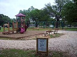
The Hayes Park includes a swing set, swing safety surround, trash bins, picnic tables, a walking trail, landscaping, and playground equipment for small children. It is located behind the Calcasieu Parish Library-Hayes Branch. In February 2010, the Bell City FFA was awarded a grant from the Lt. Governor's Learn and Serve Commission to construct the park. The FFA teamed up with several community partners for the project, including the Calcasieu Parish Ward Recreation Board.
Författare/Upphovsman: Alexrk2, Licens: CC BY 3.0
Den här Det karta skapades med GeoTools.
Författare/Upphovsman: This version: uploader
Base versions this one is derived from: originally created by en:User:Wapcaplet, Licens: CC BY 2.0
Map of USA with Louisiana highlighted


