Hawthorne, New Jersey
| Hawthorne | |
| borough | |
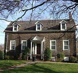
John W. Rea House | |
| Land | |
|---|---|
| Delstat | New Jersey |
| County | Passaic County |
| Höjdläge | 26 m ö.h. |
| Koordinater | 40°56′57″N 74°9′14″V / 40.94917°N 74.15389°V |
| Yta | 8,7 km² (2010) |
| - land | 8,6 km² |
| - vatten | 0,1 km² |
| Folkmängd | 19 635 (2020)[1] |
| Befolkningstäthet | 2 283 invånare/km² |
| Tidszon | EST (UTC-5) |
| - sommartid | EDT (UTC-4) |
| ZIP-kod | 07506–07507 |
| Riktnummer | 973 |
| FIPS | 3430570 |
| Geonames | 5098909 |
Ortens läge i New Jersey | |
New Jerseys läge i USA | |
| Webbplats: https://www.hawthornenj.org/ | |
Hawthorne är en kommun (borough) i Passaic County i New Jersey.[2] Vid 2020 års folkräkning hade Hawthorne 19 635 invånare.[1]
Källor
- ^ [a b] ”Hawthorne borough, New Jersey 2020 Decennial Census” (på engelska). United States Census Bureau. https://data.census.gov/profile/Hawthorne_borough,_New_Jersey?g=1600000US3430570. Läst 10 februari 2023.
- ^ Hawthorne, NJ. Map Quest. Läst 21 april 2020.
|
Media som används på denna webbplats
Shiny red button/marker widget. Used to mark the location of something such as a tourist attraction.
The John W. Rea House, which was constructed in 1810, is seen from the front in early December, 2011. The house, which is listed on both the National and New Jersey Register of Historic Places, is currently used as office space for Passaic County.
Författare/Upphovsman: This version: uploader
Base versions this one is derived from: originally created by en:User:Wapcaplet, Licens: CC BY 2.0
Map of USA with New Jersey highlighted
Författare/Upphovsman: Alexrk, Licens: CC BY 3.0
Den här Det karta skapades med GeoTools.


