Hạ Long
| Hạ Long | |
| Ha Long | |
| Stad | |
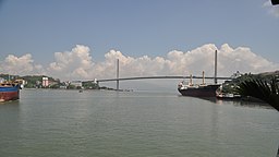
Bai Chay-bron i Hạ Long. | |
| Land | |
|---|---|
| Provins | Quảng Ninh |
| Koordinater | 20°57′32″N 107°05′27″Ö / 20.95889°N 107.09083°Ö |
| Folkmängd | |
| - stad | 270 054 (1 april 2019)[1] |
| Geonames | 1580410 |
Hạ Longs läge i Vietnam. | |
Hạ Long är en stad i nordöstra Vietnam. Den är huvudstad i provinsen Quảng Ninh. Folkmängden uppgick till cirka 270 000 invånare vid folkräkningen 2019. Staden är belägen vid Cua Luc-buktens mynning ut i den större Ha Long-bukten och administrerar en mängd öar utanför kusten, varav den största är Hang Trai.
Källor
Media som används på denna webbplats
Shiny red button/marker widget. Used to mark the location of something such as a tourist attraction.
Författare/Upphovsman: Uwe Dedering, Licens: CC BY-SA 3.0
Location map of Vietnam.
Equirectangular projection. Strechted by 104.0%. Geographic limits of the map:
* N: 24.0° N
* S: 8.0° N
* W: 101.8° E
* E: 110.3° E
Made with Natural Earth. Free vector and raster map data @ naturalearthdata.com.
Författare/Upphovsman: David McKelvey from Brisbane, Australia, Licens: CC BY 2.0
The Bai Chay Bridge connects Hon Gai with Bai Chay over the Cua Luc Straits, separating Cua Luc Bay with Halong Bay, the territory of the province Quang Ninh, Vietnam


