Guifloden
| Guifloden (桂江) | |
| Gui Jiang, Tan Shui, Kuei Chiang, Cassia, Kwei Kiang | |
| Vattendrag | |
| Land | |
|---|---|
| Provins | Guangxi |
| Höjdläge | 3 m ö.h. |
| Koordinater | 23°28′00″N 111°18′00″Ö / 23.46667°N 111.3°Ö |
| Tidszon | CT (UTC+8) |
| Geonames | 1809505 |
Läge i Kina | |
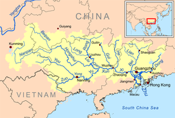
Guifloden eller Gui Jiang (桂江) är en flod i Kina.[1] Det ligger i provinsen Guangxi, i den södra delen av landet, 1 900 km söder om huvudstaden Peking.
Guifloden bildas i Pingle genom ett sammanflöde av Lifloden, Lipufloden och Gongchengfloden. Floden flyter söder ut tills den förenas som en biflod till Xifloden vid Wuzhou.[2]
Källor
- ^ Gui Jiang hos Geonames.org (cc-by); post uppdaterad 2012-01-18; databasdump nerladdad 2016-03-31
- ^ ”Guijiang River” (på engelska). Google Map. https://www.google.com/maps/place/Guijiang+River/@24.0500583,110.4284421,9z/data=!3m1!4b1!4m5!3m4!1s0x36a4511c333d9abd:0xafe863d4666a0f7e!8m2!3d24.0673067!4d110.9864686. Läst 21 november 2016.
Media som används på denna webbplats
Shiny red button/marker widget. Used to mark the location of something such as a tourist attraction.
Författare/Upphovsman: Uwe Dedering, Licens: CC BY-SA 3.0
Relief Location map of Asia.
- Projection: Lambert azimuthal equal-area projection.
- Area of interest:
- N: 90.0° N
- S: -10.0° N
- W: 45.0° E
- E: 145.0° E
- Projection center:
- NS: 40.0° N
- WE: 95.0° E
- GMT projection: -JA95/50/20.0c
- GMT region: -R45.70461034279053/-25.193892806246794/-158.9850042825966/36.990936559512505r
- GMT region for grdcut: -R-20.0/-26.0/205.0/90.0r
- Relief: SRTM30plus.
- Made with Natural Earth. Free vector and raster map data @ naturalearthdata.com.
Författare/Upphovsman: Kmusser, Licens: CC BY-SA 3.0
Map of the tributaries of the Pearl River, and the Pearl River Basin (watershed/drainage basin) in yellow.
- The Lubao Yong and Xinan Yong converge with the Liuxi River to form the main branch of the Pearl River just north of Guangzhou.
- The long and wide Pearl River Delta includes the dense network of cities that span nine prefectures of Guangdong Province, into the South China Sea.


