Guéthary
| Guéthary | ||
| Kommun | ||
 Guétharys järnvägsstation med ortens namn på både franska och baskiska | ||
| ||
| Land | ||
|---|---|---|
| Region | Nouvelle-Aquitaine | |
| Departement | ||
| Arrondissement | Bayonne | |
| Kanton | Saint-Jean-de-Luz | |
| Koordinater | 43°25′N 1°36′V / 43.417°N 1.600°V | |
| Yta | 1,4 km²[1] | |
| Folkmängd | 1 323 ()[2] | |
| Befolkningstäthet | 945 invånare/km² | |
| Tidszon | CET (UTC+1) | |
| - sommartid | CEST (UTC+2) | |
| Postnummer | 64210 | |
| INSEE | 64249 | |
| Geonames | 3014340 | |
| OSM-karta | 166719 | |
 Kommunens läge i regionen Nouvelle-Aquitaine i Frankrike | ||
| Webbplats: http://www.guethary.fr | ||

Guéthary (på baskiska Getaria) är en kommun i departementet Pyrénées-Atlantiques i sydvästra Frankrike. Guéthary ligger vid kusten mot Biscayabukten i den historiska provinsen Labourd i norra Baskien. År 2021 hade Guéthary 1 323 invånare.
Befolkningsutveckling
Antalet invånare i kommunen Guéthary
 Referens: INSEE[3] |
Galleri

 Rådhuset

Se även
Källor
- ^ Répertoire géographique des communes, Institut national de l'information géographique et forestière, läst: 26 oktober 2015.[källa från Wikidata]
- ^ Populations légales 2021, Institut National de la Statistique et des Études Économiques, 28 december 2023.[källa från Wikidata]
- ^ Chiffres clés - Évolution et structure de la population hämtat från the Wayback Machine (arkiverat 4 maj 2012).
Externa länkar
 Wikimedia Commons har media som rör Guéthary.
Media som används på denna webbplats

Författare/Upphovsman: Eric Gaba (Sting - fr:Sting), Licens: CC BY-SA 4.0
Blank physical map of metropolitan France for geo-location purpose.
Scale : 1:14 816 000 (accuracy : about 3,7 km) for the bathymetry. More maps of France, view → Commons Atlas of France.

Shiny red button/marker widget. Used to mark the location of something such as a tourist attraction.

Författare/Upphovsman: Ingen maskinläsbar skapare angavs. Harrieta171 antaget (baserat på upphovsrättsanspråk)., Licens: CC BY 2.5
Guéthary, la mairie et le fronton place libre. Photo prise le 15/10/06 par Harrieta171
_Vue_sur_la_c%c3%b4te_de_la_Terrasse_Pierre-Louis.JPG)
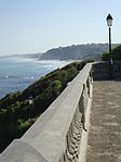
Författare/Upphovsman: Havang(nl), Licens: CC0
Guéthary (Pyr-Atl., Fr) Vue sur la côte de la Terrasse Pierre-Louis.

Författare/Upphovsman: Ingen maskinläsbar skapare angavs. Harrieta171 antaget (baserat på upphovsrättsanspråk)., Licens: CC BY 2.5
Guéthary, surfeurs sur la plage. Photo prise le 15/10/06 par Harrieta171

Författare/Upphovsman: Ingen maskinläsbar skapare angavs. Harrieta171 antaget (baserat på upphovsrättsanspråk)., Licens: CC BY 2.5
Guéthary, surfeurs sur la vague. Photo prise le 15/10/06 par Harrieta171

Författare/Upphovsman: Peter Potrowl, Licens: CC BY 2.5
Coat of arms of Guéthary (Pyrénées-Atlantiques, France)

(c) I, Peter Potrowl, CC BY 3.0
Coat of arms of the French departement Pyrénées-Atlantiques (64)

Författare/Upphovsman: Ingen maskinläsbar skapare angavs. Gruson-Daniel antaget (baserat på upphovsrättsanspråk)., Licens: CC BY-SA 2.5
Panoramique depuis les rochers de Parlementia du Samedi 2 Mars 2007
Författare/Upphovsman: Adrar, Licens: CC BY-SA 3.0
Getaria / Guéthary train station, Getaria, Lapurdi /Labourd, Basque Country.
Författare/Upphovsman: Michiel1972, Licens: CC BY-SA 3.0
Population - Municipality code 64249.svg
Population Census 1962-2008Författare/Upphovsman:
|
Map data (c) OpenStreetMap contributors, CC-BY-SA _French_municipality_map.svg) • Shape files infrastructure: railway, highways, water: all originally by OpenStreetMap contributors. Status december 2011 *note: shown commune boundaries are from OSM dump May 2012; at that time about 90% complete |
Map commune FR insee code 64249.png