Grundy County, Illinois
| Grundy County | |
| County | |
Grundy County Courthouse. | |
| Land | |
|---|---|
| Delstat | |
| Huvudort | Morris |
| Area | 1 115 km² (2010)[1] |
| - land | 1 083 km² (97%) |
| - vatten | 32,1 km² (3%) |
| Folkmängd | 50 063 (2010)[2] |
| Befolkningstäthet | 46 invånare/km² |
| Grundat | 1841 |
| - uppkallat efter | Felix Grundy |
| Tidszon | CST (UTC-6) |
| - sommartid | CDT (UTC-5) |
| FIPS-kod | 17063 |
| Geonames | 4894828 |
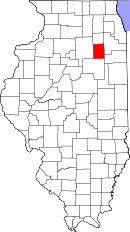
Läge i delstaten Illinois. | |
Delstatens läge i USA. | |
Grundy County är ett administrativt område i delstaten Illinois i USA. År 2010 hade countyt 50 063 invånare. Den administrativa huvudorten (county seat) är Morris.
Politik
Grundy County tenderar att rösta på republikanerna i politiska val.[3]
Republikanernas kandidat har vunnit countyt i samtliga presidentval sedan 1892 utom vid fyra tillfällen: 1912, 1932, 1996 och 2008.[3]
Geografi
Enligt United States Census Bureau har countyt en total area på 1 115 km². 1 088 km² av den arean är land och 27 km² är vatten.
Angränsande countyn
- Kendall County - nord
- Will County - öst
- Kankakee County - i sydost
- Livingston County - syd
- LaSalle County - väst
Orter
- Carbon Hill
- Channahon (delvis i Will County)
- Dwight (delvis i Livingston County)
- Minooka (delvis i Kendall County, delvis i Will County)
- Morris (huvudort)
- Verona
Referenser
- ^ ”2010 Census U.S. Gazetteer Files for Counties”. U.S. Census Bureau. Arkiverad från originalet den 5 juli 2012. https://www.webcitation.org/68vYLbou5?url=http://www.census.gov/geo/www/gazetteer/files/Gaz_counties_national.txt. Läst 5 juli 2012.
- ^ ”State & County QuickFacts, Grundy County, Illinois” (på engelska). U.S. Census Bureau. Arkiverad från originalet den 11 juli 2011. https://www.webcitation.org/605n5e5xX?url=http://quickfacts.census.gov/qfd/states/17/17063.html. Läst 6 juli 2011.
- ^ [a b] Leip, David. ”Atlas of US Presidential Elections”. uselectionatlas.org. http://uselectionatlas.org/RESULTS. Läst 17 april 2018.
|
Media som används på denna webbplats
This is a locator map showing Grundy County in Illinois. For more information, see Commons:United States county locator maps.
Författare/Upphovsman: This version: uploader
Base versions this one is derived from: originally created by en:User:Wapcaplet, Licens: CC BY 2.0
Map of USA with Illinois highlighted
Författare/Upphovsman: Teemu08, Licens: CC BY-SA 2.0
Front of the Grundy County Courthouse, located on the square bounded by Washington, Franklin, Illinois, and Liberty Streets in Morris, Illinois, United States. Built in 1913, it is a part of the Morris Downtown Commercial Historic District, a historic district that is listed on the National Register of Historic Places. Morris was selected as the Grundy County seat in 1841; the town was named after Isaac N. Morris, the president of the Illinois & Michigan Canal. This structure, the third county courthouse, was built in 1913. The granite structure in front is the Soldiers and Sailors Monument by Lorado Taft. Grundy County was founded in 1841, split off of LaSalle County. It was named for Felix Grundy, the Attorney General of the United States who died a few months earlier.


