Greenlawn
| Greenlawn | |
| CDP | |
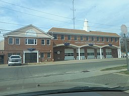
Greenlawns frivilliga brandkår | |
| Land | |
|---|---|
| Delstat | New York |
| County | Suffolk County |
| Höjdläge | 69 m ö.h. |
| Koordinater | 40°52′8″N 73°21′54″V / 40.86889°N 73.36500°V |
| Yta | 9,5 km² (2010) |
| - land | 9,5 km² |
| - vatten | 0,0 km² |
| Folkmängd | 13 742 (2010) |
| Befolkningstäthet | 1 447 invånare/km² |
| Tidszon | EST (UTC-5) |
| - sommartid | EDT (UTC-4) |
| ZIP-kod | 11740 |
| Riktnummer | 631 |
| FIPS | 3630543 |
| Geonames | 5119377 |
(c) NordNordWest, CC BY 3.0 Ortens läge i delstaten New York | |
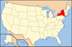
New Yorks läge i USA | |
Greenlawn är en så kallad census-designated place i Huntingtons kommun i Suffolk County på Long Island i delstaten New York. Orten är belägen i östra delen av New Yorks storstadsregion.[1][2] Vid 2010 års folkräkning hade Greenlawn 13 742 invånare.[3]
Källor
- ^ Greenlawn, NY. Map Quest. Läst 24 augusti 2019.
- ^ Profile for Greenlawn, New York Arkiverad 15 maj 2019 hämtat från the Wayback Machine.. ePodunk. Läst 24 augusti 2019.
- ^ 2010 Census Population of Greenlawn, New York Arkiverad 24 augusti 2019 hämtat från the Wayback Machine.. Census Viewer. Läst 24 augusti 2019.
|
Media som används på denna webbplats
Shiny red button/marker widget. Used to mark the location of something such as a tourist attraction.
Författare/Upphovsman: DanTD, Licens: CC BY-SA 4.0
The Greenlawn Volunteer Fire Department headquarters on Boulevard Avenue as seen from the exit of the Greenlawn Long Island Rail Road station in Greenlawn, New York.
Författare/Upphovsman: Huebi, Licens: CC BY 2.0
Map of USA with New York highlighted
(c) NordNordWest, CC BY 3.0
Location map of the State of New York, USA


