Greenbelt, Maryland
| Greenbelt | ||
| city | ||
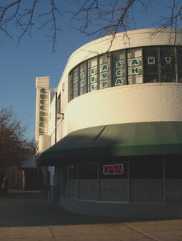
Roosevelt Center | ||
| ||
| Land | ||
|---|---|---|
| Delstat | Maryland | |
| County | Prince George's County | |
| Höjdläge | 48 m ö.h. | |
| Koordinater | 39°0′16″N 76°52′32″V / 39.00444°N 76.87556°V | |
| Yta | 16,42 km² (2010) | |
| - land | 16,27 km² | |
| - vatten | 0,15 km² | |
| Folkmängd | 23 068 (2010) | |
| Befolkningstäthet | 1 418 invånare/km² | |
| Tidszon | EST (UTC-5) | |
| - sommartid | EDT (UTC-4) | |
| ZIP-kod | 20768, 20770, 20771 | |
| Riktnummer | 240/301 | |
| FIPS | 2434775 | |
| Geonames | 4356847 | |
Ortens läge i Maryland | ||
Marylands läge i USA | ||
| Webbplats: greenbeltmd.gov | ||
Greenbelt är en stad i Prince George's County i delstaten Maryland, USA med 23 068 invånare (2010).[1]
Referenser
- ^ 2010 Census Population of Greenbelt, Maryland Arkiverad 30 juli 2017 hämtat från the Wayback Machine.. Census Viewer. Läst 30 juli 2017.
| ||||||||||
|
Media som används på denna webbplats
Författare/Upphovsman: Alexrk2, Licens: CC BY 3.0
Den här Det karta skapades med GeoTools.
Shiny red button/marker widget. Used to mark the location of something such as a tourist attraction.
Författare/Upphovsman: This version: uploader
Base versions this one is derived from: originally created by Wapcaplet, Licens: CC BY 2.0
Map of USA with Maryland highlighted
The flag of the city of Greenbelt, Maryland, designed by Mary Clare Bonham.
Roosevelt Center, Greenbelt, Maryland


