Græsted
| Græsted | |
| Ort | |
Græsteds kyrka | |
| Land | |
|---|---|
| Region | Region Hovedstaden |
| Kommun | Gribskovs kommun |
| Koordinater | 56°03′56″N 12°17′06″Ö / 56.0655°N 12.2851°Ö |
| Area | 1,9 km²[1] |
| Folkmängd | 3 627 (1 jan 2017)[2] |
| Geonames | 2621101 |
Läge i Danmark | |
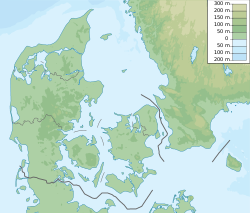
Græsted är en ort på Själland i Danmark.[3] Den ligger i Gribskovs kommun och Region Hovedstaden, 50 km norr om Köpenhamn. Antalet invånare är 3 627.[2] Närmaste större samhälle är Hillerød, 15 km söder om Græsted. Orten har två hållplatser på Gribskovbanen mellan Hillerød och Gilleleje; Græsted Syd och Græsted.
Källor
- ^ Mätning på ”SDFE kortviewer”. SDFE. Arkiverad från originalet den 13 november 2020. https://web.archive.org/web/20201113052319/https://sdfekort.dk/. Läst 12 november 2017.
- ^ [a b] ”Folketal 1. januar efter byer og tid”. Danmarks statistik. http://www.statistikbanken.dk/BY1. Läst 12 november 2017.
- ^ Græsted hos Geonames.org (cc-by); post uppdaterad 2012-05-05; databasdump nerladdad 2015-05-23
Externa länkar
 Wikimedia Commons har media som rör Græsted.
Media som används på denna webbplats
Shiny red button/marker widget. Used to mark the location of something such as a tourist attraction.
Författare/Upphovsman:
| This file was made by Thomas Hindsgaul, and should be credited as such.
If you make use of this picture outside of the Wiki community, an email to broadbeer [at] gmail.com would be appreciated. If you would like a better version of the image i.e. a higher resolution, or use it under another license please feel free to contact me. |
Græsted church, Græsted parish, Holbo Herred, Frederiksborg County, Denmark
Författare/Upphovsman: Urutseg, Licens: CC0
Denmark physical map, parameters equal to File:Denmark location map.svg


