Gouyave
| Den här artikeln behöver fler eller bättre källhänvisningar för att kunna verifieras. (2023-10) Åtgärda genom att lägga till pålitliga källor (gärna som fotnoter). Uppgifter utan källhänvisning kan ifrågasättas och tas bort utan att det behöver diskuteras på diskussionssidan. |
| Gouyave | |
| stad | |
| Land | |
|---|---|
| Indelning | Saint John |
| Höjdläge | 87[1] m ö.h. |
| Koordinater | 12°10′N 61°43′V / 12.167°N 61.717°V |
| Folkmängd | 3 378[1] |
| Tidszon | UTC-4 |
| Geonames | 3580279 |
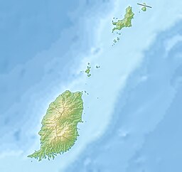
Gouyaves läge i Grenada. | |
Gouyave är en stad och huvudort i parish Saint John i Grenada. Det ligger på västkusten. Staden har 3 378 invånare och är den näst största kommunen i Grenada.
Referenser
- ^ [a b] www.fallingrain.com
Media som används på denna webbplats
Författare/Upphovsman: Tkgd2007, Licens: CC BY-SA 3.0
A new incarnation of Image:Question_book-3.svg, which was uploaded by user AzaToth. This file is available on the English version of Wikipedia under the filename en:Image:Question book-new.svg
Shiny red button/marker widget. Used to mark the location of something such as a tourist attraction.
Författare/Upphovsman: Uwe Dedering, Licens: CC BY-SA 3.0
Relief location map of Grenada.
- Projection: Equirectangular projection, strechted by 102.0%.
- Geographic limits of the map:
- N: 12.55° N
- S: 11.95° N
- W: -61.9° E
- E: -61.25° E
- GMT projection: -JX24.299333333333333cd/22.954795144615492cd
- GMT region: -R-61.9/11.95/-61.25/12.55r
- GMT region for grdcut: -R-61.9/11.95/-61.25/12.55r
- Relief: SRTM30plus.
- Made with Natural Earth. Free vector and raster map data @ naturalearthdata.com.


