Gisenyi
- För andra betydelser, se Gisenyi (olika betydelser).
| Gisenyi | |
| Stad | |
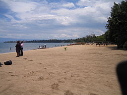
Strand i Gisenyi, vid Kivusjön. | |
| Land | |
|---|---|
| Provins | Province de l’Ouest |
| Distrikt | Rubavu |
| Höjdläge | 1 481 m ö.h. |
| Koordinater | 01°40′45″S 29°15′39″Ö / 1.67917°S 29.26083°Ö |
| Area | 11,2 km²[1] |
| Folkmängd | 53 603 (15 augusti 2012)[1] |
| Befolkningstäthet | 4 786 invånare/km² |
| Geonames | 202905 |
Gisenyis läge i Rwanda. | |
Gisenyi är en stad i nordvästra Rwanda, och är huvudort för distriktet Rubavu. Den är en av landets största städer och hade år 2015 lite mer än 50 000 invånare. Gisenyi är beläget vid Kivusjöns norra kust, vid gränsen mot Kongo-Kinshasa. Staden är sammanväxt med den betydligt större staden Goma på andra sidan gränsen. Turism är en viktig näring i området.
Källor
- ^ [a b] National Institute of Statistics of Rwanda; District Profile, Rubavu (pdf-fil) Arkiverad 22 juli 2015 hämtat från the Wayback Machine. Läst 18 juli 2015.
Media som används på denna webbplats
Flag of Rwanda. The flag ratio is 2:3 with the stripes being 2:1:1. Colors are the following officially: Pantone 299 C 2X (blue), RAL 6029 (green), RAL 1023 (yellow) and RAL 1003 (golden yellow). (As of 03/08/2010, the only color used is the Pantone 299 C, which is from here. The rest of the colors are RAL shades from here.)
Författare/Upphovsman: The original uploader was Acntx på engelska Wikipedia., Licens: CC BY-SA 3.0
Gisenyi, Rwanda Location Map with 2006 provincial boundaries; created with the GIMP. Made by en:User:Acntx.
Författare/Upphovsman: Ingen maskinläsbar skapare angavs. Amakuru antaget (baserat på upphovsrättsanspråk)., Licens: CC BY-SA 3.0
The beach on Lake Kivu at Gisenyi, Rwanda
Taken by SteveRwanda


