Gila County
| Gila County | |
| County | |
Domstolsbyggnaden i Gila County. | |
| Land | |
|---|---|
| Delstat | |
| Huvudort | Globe |
| Största stad | Payson |
| Area | 12 420 km² (2010)[1] |
| - land | 12 323 km² (99%) |
| - vatten | 97,1 km² (1%) |
| Folkmängd | 53 597 (2010)[2] |
| Befolkningstäthet | 4,3 invånare/km² |
| Grundat | 1881 |
| Tidszon | MST (UTC-7) |
| FIPS-kod | 04007 |
| Geonames | 5295877 |
Läge i delstaten Arizona. | |
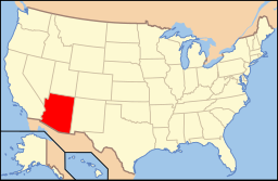
Delstatens läge i USA. | |
Gila County är ett county och ligger i centrala delen av delstaten Arizona i USA. Enligt folkräkningen år 2010 var countyts folkmängd 53 597. Den administrativa huvudorten (county seat) är Globe.
Tonto nationalmonument ligger i countyt.
Geografi
Enligt United States Census Bureau har countyt en total area på 12 421 km². 12 348 km² av den arean är land och 73 km² är vatten.
Angränsande countyn
- Yavapai County, Arizona - nordväst
- Maricopa County, Arizona - väst
- Pinal County, Arizona - syd
- Graham County, Arizona - sydöst
- Navajo County, Arizona - öst, nordöst
- Coconino County, Arizona - nord
Orter

Större stad (City)
- Globe (huvudort)
Mindre städer (Towns)
Småstäder med kommunalt självstyre.
- Hayden (delvis i Pinal County)
- Miami
- Payson
- Star Valley
- Winkelman (delvis i Pinal County)
Census-designated places
Census-designated places är i allmänhet mindre orter som saknar kommunalt självstyre.
- Bear Flat
- Beaver Valley
- Canyon Day
- Carrizo
- Cedar Creek
- Central Heights-Midland City
- Christopher Creek
- Claypool
- Copper Hill
- Cutter
- Deer Creek
- Dripping Springs
- East Globe
- East Verde Estates
- El Capitan
- Flowing Springs
- Freedom Acres
- Geronimo Estates
- Gisela
- Haigler Creek
- Hunter Creek
- Icehouse Canyon
- Jakes Corner
- Kohls Ranch
- Mead Ranch
- Mesa del Caballo
- Oxbow Estates
- Peridot
- Pinal
- Pine
- Rock House
- Roosevelt
- Round Valley
- Rye
- San Carlos
- Six Shooter Canyon
- Strawberry
- Tonto Basin
- Tonto Village
- Top-of-the-World
- Washington Park
- Wheatfields
- Whispering Pines
- Young
Övriga mindre orter
- Coffeepot
- Dagger
- Inspiration
- Punkin Center
Referenser
- ^ ”2010 Census U.S. Gazetteer Files for Counties”. U.S. Census Bureau. Arkiverad från originalet den 5 juli 2012. https://www.webcitation.org/68vYLbou5?url=http://www.census.gov/geo/www/gazetteer/files/Gaz_counties_national.txt. Läst 5 juli 2012.
- ^ ”State & County QuickFacts, Gila County, Arizona” (på engelska). U.S. Census Bureau. Arkiverad från originalet den 10 juli 2011. https://www.webcitation.org/604hGRn6V?url=http://quickfacts.census.gov/qfd/states/04/04007.html. Läst 6 juli 2011.
| ||||||||||
Media som används på denna webbplats
Författare/Upphovsman: Huebi, Licens: CC BY 2.0
Map of USA with Arizona highlighted
Författare/Upphovsman: Ken Lund, Licens: CC BY-SA 2.0
Gila County courthouse in Globe, Arizona
Locator map of Gila County in Arizona.
- This map shows the incorporated areas and unincorporated areas in Gila County, Arizona. Incorporated cities are shown in gray and unincorporated communities or CDPs are shown in white.
- Credits
- Data for the borders and locations are based on maps from the US Census Bureau TIGER Map Server.
- I created this map in Inkscape.


