Getinge, Eslövs kommun
| Den här artikeln behöver källhänvisningar för att kunna verifieras. (2019-01) Åtgärda genom att lägga till pålitliga källor (gärna som fotnoter). Uppgifter utan källhänvisning kan ifrågasättas och tas bort utan att det behöver diskuteras på diskussionssidan. |
| Getinge | |
| By | |
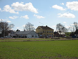
Vy över Getinges centrum. | |
| Land | |
|---|---|
| Landskap | Skåne |
| Län | Skåne län |
| Kommun | Eslövs kommun |
| Distrikt | Gårdstånga-Holmby distrikt |
| Koordinater | 55°45′45″N 13°18′45″Ö / 55.76250°N 13.31250°Ö |
| Tidszon | CET (UTC+1) |
| - sommartid | CEST (UTC+2) |
| Postort | Flyinge |
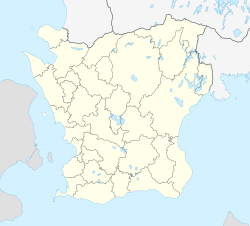
Getinges läge i Skåne län. | |
Getinge är en ort i Eslövs kommun i Skåne län, belägen strax intill Gårdstånga vid gamla E66 (nuvarande E22 går strax utanför).
Getinge är byggt på en sluttning med flera hus som ligger i "Dalen", en tidigare bäckfåra som under 1900-talet bebyggts med bostadshus.
Getinge har gett namn åt Getingevägen i Lund, som är den huvudsakliga vägen ut ur staden åt nordost.
Se även
Media som används på denna webbplats
Författare/Upphovsman: Tkgd2007, Licens: CC BY-SA 3.0
A new incarnation of Image:Question_book-3.svg, which was uploaded by user AzaToth. This file is available on the English version of Wikipedia under the filename en:Image:Question book-new.svg
Författare/Upphovsman: Erik Frohne, Licens: CC BY 3.0
Location map of Scania (Skåne) in Sweden
Equirectangular projection, N/S stretching 179 %. Geographic limits of the map:
- N: 56° 37' N
- S: 55° 12' N
- W: 12° 12' E
- E: 15° 00' E
Shiny red button/marker widget. Used to mark the location of something such as a tourist attraction.


