Geostationär omloppsbana
| Den här artikeln behöver källhänvisningar för att kunna verifieras. (2024-02) Åtgärda genom att lägga till pålitliga källor (gärna som fotnoter). Uppgifter utan källhänvisning kan ifrågasättas och tas bort utan att det behöver diskuteras på diskussionssidan. |


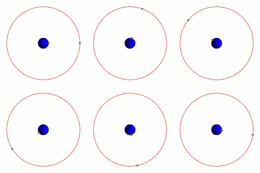
Den geostationära omloppsbanan är en cirkulär omloppsbana i jordens ekvatorialplan, på ett sådant avstånd att en satellit i denna bana roterar runt jorden i samma riktning och med samma omloppstid som jordens rotationstid. Det finns bara en enda sådan bana, då satelliter på lägre höjd måste snurra snabbare för att inte ramla ner och satelliter på högre höjd måste snurra långsammare för att inte kastas ut i rymden.
Beskrivning
En satellit i geostationär bana kommer alltså att hålla en fast position ovanför en punkt på jordytan, och den används därför av många satelliter för TV- och radiokommunikation.
Som ett resultat av att en satellit i en sådan omloppsbana håller sig ovanför en fast punkt på jordytan kan en antenn på marken hålla kontakt med satelliten bara genom att hålla en fast riktning mot den. För att uppnå detta måste satelliten kretsa ca 35 790 km direkt ovanför ekvatorn, med små felmarginaler. Avståndet är betydelsefullt, eftersom det producerar en omloppstid exakt lika med jordens rotationstid, stjärndygnet.
Den geostationära banan är ett specialfall av geosynkrona omloppsbanor, vilka har samma omloppstid men inte behöver vara cirkulära eller hålla sig i ekvatorialplanet. Alla geosynkrona banor i ekvatorialplanet måste dock korsa den geostationära banan och därmed riskeras kollision med satelliter där. I praktiken betyder detta att endast den geostationära banan utnyttjas för satelliter.
För att minska risken för kollisioner i geostationär bana skall geostationära satelliter placeras i en begravningsbana när de tas ur drift.
Användningen av den geostationära banan för kommunikationssatelliter populariserades först av författaren Arthur C. Clarke år 1945. Som hedersbevis på detta kallas den ibland Clarke-banan.
GTO
Det är vanligt att raketer placerar satelliter som ska till Geostationär omloppsbana i en geostationär transferbana (Geostationary transfer orbit) (GTO), istället. Satelliten får sen själv göra de sista banförändringarna för att hamna i Geostationär omloppsbana. GTO är en Hohmannbana där Apsis ligger vid Geostationär omloppsbana.
Eftersom raketens sista steg inte behöver stå för de sista banförändringarna, då satelliten placeras i sin slutgiltiga omloppsbana, så kan raketen i praktiken skjuta upp tyngre satelliter till Geostationär omloppsbana.
Geostationära banans höjd över jordens yta
Cirka 35 790 km direkt ovanför ekvatorn
Beräkning av den geostationära banans höjd
För att beräkna jordens geostationära banas höjd används formeln (beteckningar enligt nedan):
(avståndet från jordens centrum). Subtraheras jordytans ekvatorradie, 6378 km, får man höjden som nämns ovan.
Härledning
Eftersom satellitens centripetalkraft balanseras av gravitationskraften i en cirkulär bana[1] har vi (enligt Newtons gravitationslag):
- där
betecknar satellitens massa, jordens massa, avståndet från jordens masscentrum till satelliten, satellitens banhastighet och gravitationskonstanten. Eftersom omloppsbanans längd är lika med har vi att , där är satellitens omloppstid, det vill säga längden på ett sideriskt dygn (satelliten skall ju rotera lika fort som jorden i förhållande till universum). Vi får således:
och då vinkelhastigheten ger detta
Referenser
- Robert A. Braeunig, Orbital mechanics.
Noter
- ^ Banan måste vara cirkulär, annars kommer satelliten inte att hålla en konstant vinkelhastighet och därför inte vara stationär över samma punkt.
Se även
Externa länkar
 Wikimedia Commons har media som rör Geostationär omloppsbana.
| |||||||||||||||||||||||||||||||||
Media som används på denna webbplats
Författare/Upphovsman: Tkgd2007, Licens: CC BY-SA 3.0
A new incarnation of Image:Question_book-3.svg, which was uploaded by user AzaToth. This file is available on the English version of Wikipedia under the filename en:Image:Question book-new.svg
A scale diagram showing earth and various orbits above it.
bendera Indonesia
MAVEN at Mars, Artist's Concept. This artist's concept depicts NASA's Mars Atmosphere and Volatile EvolutioN (MAVEN) spacecraft near Mars. MAVEN is in development for launch in 2013 and will be the first mission devoted to understanding the Martian upper atmosphere. The mission's principal investigator is Bruce Jakosky from the Laboratory for Atmospheric and Space Physics at the University of Colorado.
The goal of MAVEN is to determine the role that loss of atmospheric gas to space played in changing the Martian climate through time. MAVEN will determine how much of the Martian atmosphere has been lost over time by measuring the current rate of escape to space and gathering enough information about the relevant processes to allow extrapolation backward in time.
NASA Goddard Space Flight Center in Greenbelt, Md. manages the project and will also build some of the instruments for the mission. In addition to the principal investigator coming from CU-LASP, the university will provide science operations, build instruments, and lead education/public outreach. Lockheed Martin of Littleton, Colo., is building the spacecraft and will perform mission operations. The University of California-Berkeley Space Sciences Laboratory is also building instruments for the mission. NASA's Jet Propulsion Laboratory, Pasadena, Calif., will provide navigation support, the Deep Space Network, and the Electra telecommunications relay hardware and operations.
For more information about MAVEN, visit www.nasa.gov/maven.Flag of Iran. The tricolor flag was introduced in 1906, but after the Islamic Revolution of 1979 the Arabic words 'Allahu akbar' ('God is great'), written in the Kufic script of the Qur'an and repeated 22 times, were added to the red and green strips where they border the white central strip and in the middle is the emblem of Iran (which is a stylized Persian alphabet of the Arabic word Allah ("God")).
The official ISIRI standard (translation at FotW) gives two slightly different methods of construction for the flag: a compass-and-straightedge construction used for File:Flag of Iran (official).svg, and a "simplified" construction sheet with rational numbers used for this file.
The Flag of Europe is the flag and emblem of the European Union (EU) and Council of Europe (CoE). It consists of a circle of 12 golden (yellow) stars on a blue background. It was created in 1955 by the CoE and adopted by the EU, then the European Communities, in the 1980s.
The CoE and EU are distinct in membership and nature. The CoE is a 47-member international organisation dealing with human rights and rule of law, while the EU is a quasi-federal union of 27 states focused on economic integration and political cooperation. Today, the flag is mostly associated with the latter.
It was the intention of the CoE that the flag should come to represent Europe as a whole, and since its adoption the membership of the CoE covers nearly the entire continent. This is why the EU adopted the same flag. The flag has been used to represent Europe in sporting events and as a pro-democracy banner outside the Union.Flag of Israel. Shows a Magen David (“Shield of David”) between two stripes. The Shield of David is a traditional Jewish symbol. The stripes symbolize a Jewish prayer shawl (tallit).


