Gémozac
| Gémozac | ||
| Kommun | ||
 | ||
| ||
| Land | ||
|---|---|---|
| Region | Nouvelle-Aquitaine | |
| Departement | ||
| Arrondissement | Saintes | |
| Kanton | Gémozac | |
| Koordinater | 45°34′N 0°40′V / 45.567°N 0.667°V | |
| Yta | 31,93 km²[1] | |
| Folkmängd | 2 989 ()[2] | |
| Befolkningstäthet | 94 invånare/km² | |
| Postnummer | 17260 | |
| INSEE | 17172 | |
| Geonames | 3016392 | |
| OSM-karta | 126518 | |
 Kommunens läge i regionen Nouvelle-Aquitaine i Frankrike | ||
| Webbplats: http://www.gemozac.fr/ | ||

Gémozac är en kommun i västra Frankrike, belägen i departementet Charente-Maritime i regionen Nouvelle-Aquitaine.
Läge
Gémozac ligger 92 km sydöst om La Rochelle, som är huvudstad i Charente-Maritime och 90 km norr om Bordeaux, den stora staden i sydvästra Frankrike. Byn ligger också 60 km sydväst om Rochefort, 30 km öster om Royan och 22 km söder om Saintes, de tre andra huvudorterna i Charente-Maritime. Gémozac ligger 10 km väster om Pons.
Byn ligger söder om den gamla provinsen av Saintonge.
Näringsliv

Byn är framför allt känd som livsmedelsindustriscentrum i Charente-Maritime med spritfabriker (konjak) och stora silor.
Gémozac är en handelsplats med köpcentrum och en historisk ort.
Befolkning
Gémozac är en by med ungefär 2 600 invånare[3]. År 1946 hade orten omkring 2 100 invånare och ungefär 2 400 år 1975.
Dess invånare kallas på franska Gémozacaises (f) och Gémozacais (m).
Befolkningsutveckling
Antalet invånare i kommunen Gémozac
 Referens: INSEE[4] |
Bilder på Gémozac
 Gémozac stadshus.
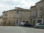 Gémozac torget.
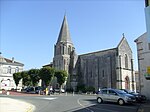 Den gamla kyrka från medeltiden.
 Den protestanta tempel.
Se även
Källor
- ^ Répertoire géographique des communes, Institut national de l'information géographique et forestière, läst: 26 oktober 2015, licens: öppen licens.[källa från Wikidata]
- ^ Populations légales 2021, Institut National de la Statistique et des Études Économiques, 28 december 2023.[källa från Wikidata]
- ^ Population municipale Befolkningsstatistik om kommuner i Charente-Maritime
- ^ Chiffres clés - Évolution et structure de la population
Externa länkar
 Wikimedia Commons har media som rör Gémozac.
Media som används på denna webbplats


Författare/Upphovsman: Eric Gaba (Sting - fr:Sting), Licens: CC BY-SA 4.0
Blank physical map of metropolitan France for geo-location purpose.
Scale : 1:14 816 000 (accuracy : about 3,7 km) for the bathymetry. More maps of France, view → Commons Atlas of France.

Shiny red button/marker widget. Used to mark the location of something such as a tourist attraction.
Författare/Upphovsman: Michiel1972, Licens: CC BY-SA 3.0
Population - Municipality code 17172.svg
Population Census 1962-2008
Författare/Upphovsman: Serge Lacotte, Licens: CC BY-SA 3.0
Vue générale de l'Hôtel-de-ville de Gémozac (17).
Författare/Upphovsman:
|
Map data (c) OpenStreetMap contributors, CC-BY-SA _French_municipality_map.svg) • Shape files infrastructure: railway, highways, water: all originally by OpenStreetMap contributors. Status december 2011 *note: shown commune boundaries are from OSM dump May 2012; at that time about 90% complete |
Map commune FR insee code 17172.png
.svg)

Författare/Upphovsman: Serge Lacotte, Licens: CC BY-SA 3.0
Place centrale de Gémozac face à l'église (17).
Författare/Upphovsman: Serge Lacotte, Licens: CC BY-SA 3.0
Rue principale de Gémozac (17).
Författare/Upphovsman: Cobber17, Licens: CC BY 3.0
Une vue de Gémozac (Charente-Maritime)

Författare/Upphovsman: Serge Lacotte, Licens: CC BY-SA 3.0
Le Temple protestant de Gémozac (17)

Författare/Upphovsman: Cobber17, Licens: CC BY 3.0
L'église Saint-Pierre de Gémozacavec la place et la mairie.