Fougères
| Fougères | ||
| Kommun | ||
 | ||
| ||
| Land | ||
|---|---|---|
| Region | ||
| Departement | ||
| Arrondissement | Fougères-Vitré (chef-lieu) | |
| Kanton | chef-lieu för 2 kantoner | |
| Koordinater | 48°21′N 1°12′V / 48.350°N 1.200°V | |
| Yta | 10,46 km²[1] | |
| Folkmängd | 20 653 ()[2] | |
| Befolkningstäthet | 1 974 invånare/km² | |
| Borgmästare | Louis Feuvrier (2007–) | |
| Tidszon | CET (UTC+1) | |
| - sommartid | CEST (UTC+2) | |
| Postnummer | 35300 | |
| INSEE | 35115 | |
| Geonames | 6454042 3017609 | |
| OSM-karta | 163995 | |
 Kommunens läge i regionen Bretagne i Frankrike | ||
| Webbplats: http://www.fougeres.fr | ||

Fougères är en stad och kommun i departementet Ille-et-Vilaine i regionen Bretagne i nordvästra Frankrike. Kommunen är belägen i floddalen runt floden Nançon. År 2021 hade Fougères 20 653 invånare. Kommune är sous-préfecture för departementet Ille-et-Vilaine.
Stadens historia går tillbaka till medeltiden, och slottet i Fougères omnämns i bevarade skrifter från 900-talet.
Befolkningsutveckling
Antalet invånare i kommunen Fougères
Referens:INSEE[3]
Galleri


 (c) Coyau / Wikimedia Commons, CC BY-SA 3.0
 Vy från slottet
 Slottet
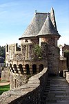


Se även
Källor
- ^ Répertoire géographique des communes, Institut national de l'information géographique et forestière, läst: 26 oktober 2015, licens: öppen licens.[källa från Wikidata]
- ^ Populations légales 2021, Institut National de la Statistique et des Études Économiques, 28 december 2023.[källa från Wikidata]
- ^ Chiffres clés - Évolution et structure de la population Arkiverad 5 juli 2012 hämtat från the Wayback Machine.
Externa länkar
 Wikimedia Commons har media som rör Fougères.
Media som används på denna webbplats

Författare/Upphovsman: Eric Gaba (Sting - fr:Sting), Licens: CC BY-SA 4.0
Blank physical map of metropolitan France for geo-location purpose.
Scale : 1:14 816 000 (accuracy : about 3,7 km) for the bathymetry. More maps of France, view → Commons Atlas of France.

Shiny red button/marker widget. Used to mark the location of something such as a tourist attraction.

(c) Indian Joe at the English Wikipedia, CC BY-SA 3.0
Tour Nichot des remparts de Fougères

Hôtel La Belinaye à Fougères et statue d'Armand Tuffin de La Rouërie

Författare/Upphovsman: Ingen maskinläsbar skapare angavs. Ofol antaget (baserat på upphovsrättsanspråk)., Licens: CC BY 2.5
Eglise St Léonard et jardin public - Fougères - Bretagne, France

Författare/Upphovsman: Chatsam, Licens: CC BY-SA 3.0
blason de la commune de Fougères, france


(c) Coyau / Wikimedia Commons, CC BY-SA 3.0
Couvent des Clarisses Urbanistes de Fougères, face sud.


Författare/Upphovsman: Pymouss, Licens: CC BY-SA 3.0
Façade de l’hôtel de ville de Fougères.
Marché Rue Nationale à Fougères (35) vu du clocher de l'église Saint-Léonard.

Författare/Upphovsman: Pymouss, Licens: CC BY-SA 3.0
Musée Emmanuel de la Villéon à Fougères, façade nord. En arrière-plan, l’église Saint-Léonard.
Författare/Upphovsman:
|
Map data (c) OpenStreetMap contributors, CC-BY-SA _French_municipality_map.svg) • Shape files infrastructure: railway, highways, water: all originally by OpenStreetMap contributors. Status december 2011 *note: shown commune boundaries are from OSM dump May 2012; at that time about 90% complete |
Map commune FR insee code 35115.png

Författare/Upphovsman: Clemensfranz, Licens: CC BY-SA 3.0
Le château de Fougères (35). De gauche à droite: les tours de Guémadeuc, de la Haye-Saint-Hilaire et du Hallay.

Château de Fougères: tours Surienne, Raoul et Mélusine (de gauche à droite).

Fougères - Kirche Saínt Léonard