Fort Myers
| Fort Myers | |
| city | |
Fort Myers, Florida | |
| Land | |
|---|---|
| Delstat | Florida |
| County | Lee County |
| Koordinater | 26°37′8″N 81°49′55″V / 26.61889°N 81.83194°V |
| Yta | 127 km² (2010)[1] |
| - land | 103 km² |
| - vatten | 23,4 km² |
| Folkmängd | 62 298 (2010)[2] |
| Befolkningstäthet | 605 invånare/km² |
| Tidszon | EST (UTC-5) |
| - sommartid | EDT (UTC-4) |
| ZIP-kod | 33901, 33903, 33905, 33907, 33912–33913, 33916–33917, 33919, 33966, 33971, 33990[3] |
| FIPS | 1224125 |
| Geonames | 4155995 |
Ortens läge i Florida | |
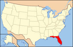
Floridas läge i USA | |
| Webbplats: http://www.cityftmyers.com | |
Fort Myers är en stad i Lee County i södra USA. Den ligger på Floridas västkust vid floden Caloosahatchee River.
Källor
- ^ ”2010 Census Gazetteer Files”. US Census Bureau. Arkiverad från originalet den 14 juli 2012. https://www.webcitation.org/699nOulzi?url=http://www.census.gov/geo/www/gazetteer/files/Gaz_places_national.txt. Läst 14 juli 2012.
- ^ ”Fort Myers (city), Florida” (på engelska). State & County Quickfacts. U.S. Census Bureau,. Arkiverad från originalet den 9 juli 2012. https://www.webcitation.org/691daxIZW?url=http://quickfacts.census.gov/qfd/states/12/1224125.html. Läst 9 juli 2012.
- ^ ”2010 ZIP Code Tabulation Area (ZCTA) Relationship Files”. U.S. Census Bureau. 14 december 2010. Arkiverad från originalet den 25 augusti 2012. https://www.webcitation.org/6ABdwXxbq?url=http://www.census.gov/geo/www/2010census/zcta_rel/zcta_place_rel_10.txt. Läst 25 augusti 2012.
Externa länkar
Media som används på denna webbplats
Shiny red button/marker widget. Used to mark the location of something such as a tourist attraction.
Författare/Upphovsman: This version: en:User:Huebi
Base versions this one is derived from: originally created by en:User:Wapcaplet, Licens: CC BY 2.0
Map of USA with Florida highlighted
(c) ReignMan på engelska Wikipedia, CC BY 3.0
Downtown Fort Myers, sans the city's high rise buildings, which are to the northeast of this photo.


