Fort Benton
| Fort Benton | |
| city | |
St. Paul's Episcopal Church | |
| Land | |
|---|---|
| Delstat | Montana |
| County | Chouteau County |
| Höjdläge | 799 m ö.h. |
| Koordinater | 47°49′10″N 110°40′11″V / 47.81944°N 110.66972°V |
| Yta | 5,4 km² (2010) |
| - land | 5,4 km² |
| - vatten | 0,0 km² |
| Folkmängd | 1 464 (2010) |
| Befolkningstäthet | 271 invånare/km² |
| Tidszon | MST (UTC-7) |
| - sommartid | MDT (UTC-6) |
| ZIP-kod | 59442 |
| FIPS | 3028000 |
| Geonames | 5652763 |
Ortens läge i Montana | |
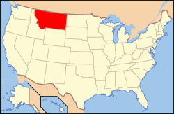
Montanas läge i USA | |
| Webbplats: http://www.fortbenton.com/ | |
Fort Benton är administrativ huvudort i Chouteau County i Montana.[1] Orten har fått sitt namn efter Thomas Hart Benton.[2]
Källor
- ^ Montana County Map with County Seat Cities. Geology.com Geoscience News and Information. Läst 23 maj 2016.
- ^ Profile for Fort Benton, Montana Arkiverad 24 juni 2016 hämtat från the Wayback Machine.. ePodunk. Läst 23 maj 2016.
Externa länkar
Media som används på denna webbplats
Författare/Upphovsman: Alexrk2, Licens: CC BY 3.0
Location map of Montana, USA
Shiny red button/marker widget. Used to mark the location of something such as a tourist attraction.
Författare/Upphovsman: This version: uploader
Base versions this one is derived from: originally created by en:User:Wapcaplet, Licens: CC BY 2.0
Map of U.S. with Montana highlighted
Författare/Upphovsman: JERRYE AND ROY KLOTZ MD, Licens: CC BY-SA 3.0
BUILT IN 1880-1881; IT IS THEOLDEST EPISCOPAL CHURCH IN MONTANA AND THE OLDEST CHURCH IN FORT BENTON


