Fort


Fort är en typ av permanent befästning.[1] Ordet används framförallt för koloniala utposter. Det kan även beteckna berganläggningar som var för sig inte är så imponerande men tillsammans bildar en fästning. Exempelvis utgjordes huvuddelen av både Vabergets fästning och Bodens fästning av ett antal fort insprängda i urberget.
Ett fort är i allmänhet mindre än en fästning men ändå nog befäst för att det ska kunna genomföra en strid på egen hand.[1]
Svenska fort
- Bodens fästning med forten: Degerbergsfortet, Gammelängsfortet, Rödbergsfortet, Mjösjöfortet och Södra Åbergsfortet
- Byviksfortet
- Ellenabbsfortet
- Myttingefortet
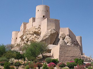
- Oscar II:s fort
- Vabergsforten med norra och södra fortet
- Vretafortet
- 12:e batteriet på Rindö
Bilder
 Fort och missions-stationen Alamo, nära San Antonio i Texas, byggd av spanska missionärer. Platsen för det blodiga slaget vid Alamo 1836, då fortet försvarades av revolutionerande innevånare i Texas, och anfölls av mexikanska regeringstrupper.
 Sydstatstruppers anfall på Fort Sumter i Charleston, South Carolina, inledde det amerikanska inbördeskriget 1861.
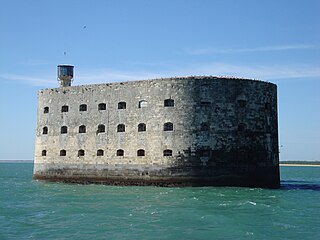 Fort Boyard, sydväst om La Rochelle på franska atlantkusten, färdigställt 1857. Seden tre decennier tillbaka inspelningsplats för Fångarna på fortet.
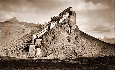
 Tysk flygbild av det sönderskjutna Fort de Douaumont, det starkaste av forten runt den franska staden Verdun, under första världskriget. Fortet intogs snabbt, men återtogs med stora förluster i människoliv under Slaget vid Verdun 1916.
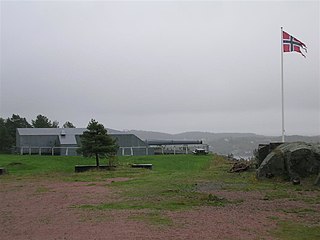 Møvik fort nära Kristiansand i Norge. Anlagd som Batterie Vara av tyskarna under andra världskriget, som en del i befästningslinjen Atlantvallen.

Se även
Referenser
Noter
- ^ [a b] i Nationalencyklopedins nätupplaga. Läst 30 augusti 2017.
Tryckta källor
- Högberg, Leif (2019). Fortet : boken om Oscar II fort. [Skurup]: Fort & bunker. Libris jtqdght3g645pk99. ISBN 9789163996399
Media som används på denna webbplats

Attack against Fort Sumter - 1861
Författare/Upphovsman: Markus Schweiß, Licens: CC BY-SA 3.0
Wirkung einer Hohlladung auf die Panzerung von Fort Eben-Emael.


Fort Douaumont Ende 1916

Författare/Upphovsman: Ken, Licens: CC BY-SA 3.0
38cm cannon at Batterie Vara in Kristiandsand Norway
Författare/Upphovsman: The original uploader was Johan Elisson på engelska Wikipedia., Licens: CC BY-SA 2.5
Rödberget fort, part of en:Boden Fortress seen from the north.

Entitled: Kampa Dzong, Tibet [1904] John C. White [RESTORED] The image was nearly perfect to begin with. I smoothed out the clouds, got rid of some minor spot and scratch problems, evened the tones and added a bit more contrast. (I had previously wrongly attributed this image to John Baptist Noel, one of White's contemporaries in the region and another historical photography figure in his own right; my humble apologies to all viewers for the glaring error.)
"British amateur photographer, who served in the Indian Public Works Department from 1876 and as political agent for Sikkim, Bhutan, and Tibetan affairs 1905–8. White accompanied the Younghusband Mission to Tibet in 1903–4 and during the campaign made a series of mainly landscape photographs, including a number of impressive panoramas. A selection of these was later issued in two photogravure volumes by the Calcutta photographers Johnston & Hoffmann as Tibet and Lhasa (1906). Owing to political sensitivities regarding the accompanying text, they were subsequently withdrawn, and are now extremely rare. A memoir, Sikhim and Bhutan: Experiences of Twenty Years on the North‐Eastern Frontier of India, appeared in 1909, and many of White's photographs accompany the articles on Sikkim and Bhutan which he later wrote for the National Geographic Magazine."
Quoted from: John Claude White Biography - (1853–1918), Tibet and Lhasa <a href="http://arts.jrank.org/pages/11649/John-Claude-White.html#ixzz0rWQ9hPl7" rel="nofollow">arts.jrank.org/pages/11649/John-Claude-White.html#ixzz0rW...</a>
Kampa Dzong (trad. Khamber Jong; also Khampa Dzong), also referred to as the Tibetan hamlet of Gamba, sits just north of the point where Nepal, India (Sikkim) and Bhutan currently abuts the Chinese border.
Tibet sat on the crossroads of history in the early 1900's, with a British force seeking to secure the northern border of its subcontinent possessions against incursion. Britain was alarmed that China was reportedly allowing unopposed Russian access to Tibet, thus putting another colonial power immediately north of India. As a prelude to that conflict, the British regional authorities attempted to negotiate with both Tibet and China and seek agreements with both governments. The meeting place was supposed to be at Kampa Dzong, see below:
"The causes of the war are obscure, and it seems to have been primarily provoked by rumours circulating amongst the Calcutta-based British administration (Delhi was made imperial capital of India in 1911) that the Chinese government, (who nominally controlled Tibet), were planning to turn it over to the Russians, thus providing Russia with a direct route to British India and breaking the chain of semi-independent, mountainous buffer-states which separated India from the Russian Empire to the north. These rumours were seemingly supported by the facts of Russian exploration of Tibet. Russian explorer Gombojab Tsybikov was the first photographer of Lhasa, residing in it in 1900—1901 with the aid of the thirteenth Dalai Lama's Russian courtier Agvan Dorjiyev.
In view of the rumors, the Viceroy, Lord Curzon in 1903 sent a request to the governments of China and Tibet for negotiations to be held at Khampa Dzong (Khamber Jong), a tiny Tibetan village north of Sikkim to establish trade agreements. The Chinese were willing, and ordered the thirteenth Dalai Lama to attend. However, the Dalai Lama refused, and also refused to provide transportation to enable the amban (the Chinese official based in Lhasa), You Tai, to attend. Curzon concluded that China had no power or authority to compel the Tibetan government, and gained approval from London to send a military expedition, led by Colonel Francis Younghusband, to Khampa Dzong. When no Tibetan or Chinese officials met them there, Younghusband advanced, with some 1,150 soldiers, 10,000 porters and laborers, and thousands of pack animals, to Tuna, fifty miles beyond the border. After waiting more months there, hoping in vain to be met by negotiators, the expedition received orders (in 1904) to continue toward Lhasa.
Tibet's government, guided by the Dalai Lama was understandably unhappy about the presence of a large acquisitive foreign power dispatching a military mission to its capital, and began marshalling its armed forces. The government was fully aware that no help could be expected from the Chinese government, and so intended to use their arduous terrain and mountain-trained army to block the British path. The British authorities had also thought of the trials mountain fighting would pose, and so dispatched a force heavy with Gurkha and Pathan troops, who came from mountainous regions of British India. The entire British force numbered just over 3,000 fighting men and was accompanied by 7,000 sherpas, porters and camp followers. Permission for the operation was received from London, but it is not clear that the Balfour government was fully aware of the scale of the operation, or of the Tibetan intention to resist it."
Source: <a href="http://www.absoluteastronomy.com/topics/British_expedition_to_Tibet" rel="nofollow">www.absoluteastronomy.com/topics/British_expedition_to_Tibet</a>