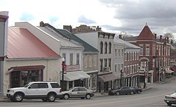
Flemingsburg
| Flemingsburg | |
| Stad (city) | |
| Uppkallad efter: John Fleming | |
| Land | |
|---|---|
| Delstat | |
| County | Fleming County |
| Höjdläge | 248 m ö.h. |
| Koordinater | 38°25′14″N 83°44′15″V / 38.42056°N 83.73750°V |
| Area | 5,29 km² (2010)[1] |
| Folkmängd | 2 953 (2020)[2] |
| Befolkningstäthet | 559 invånare/km² |
| Tidszon | EST (UTC-5) |
| - sommartid | EDT (UTC-4) |
| ZIP-kod | 41041 |
| Riktnummer | 606 |
| GNIS-kod | 492237 |
| Geonames | 4291905 |
Översiktskarta | |
Kentuckys läge i USA | |
| Wikimedia Commons: Flemingsburg, Kentucky | |
| Redigera Wikidata | |
Flemingsburg är en stad i Fleming County i delstaten Kentucky, USA. År 2000 hade orten 3 010 invånare. Den har enligt United States Census Bureau en area på 6,9 km², varav 0,2 km² är vatten.
Flemingsburg är administrativ huvudort (county seat) i Fleming County.
Referenser
- ^ United States Census Bureau, 2010 U.S. Gazetteer Files, United States Census Bureau, 2010, läst: 9 juli 2020.[källa från Wikidata]
- ^ United States Census Bureau (red.), USA:s folkräkning 2020, läs online, läst: 1 januari 2022.[källa från Wikidata]
Media som används på denna webbplats
(c) DemocraticLuntz på engelska Wikipedia, CC BY-SA 4.0
Location of Flemingsburg in Fleming County, Kentucky.
FIPS code: 21-27856
Own work, based on concept by Arkyan, using Census Bureau Tiger GIS data and a custom fork of Kartography adapted for this purpose, available atFörfattare/Upphovsman: This version: uploader
Base versions this one is derived from: originally created by en:User:Wapcaplet, Licens: CC BY 2.0
Map of USA with Kentucky highlighted
Författare/Upphovsman: FloNight (Sydney Poore) and Russell Poore, Licens: CC BY-SA 4.0
Downtown Flemingsburg, Kentucky across from the Fleming County courthouse.
|
This is an image of a place or building that is listed on the National Register of Historic Places in the United States of America. Its reference number is 85001479. |


