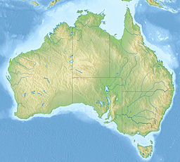
Fitzroy River, Queensland
Artikeln bygger troligen på en alltför oprecis koordinatangivelse
|
| Den här artikeln har skapats av Lsjbot, ett program (en robot) för automatisk redigering. (2015-12) Artikeln kan innehålla fakta- eller språkfel, eller ett märkligt urval av fakta, källor eller bilder. Mallen kan avlägsnas efter en kontroll av innehållet (vidare information) |
| Fitzroy River | |
| Vattendrag | |
| Land | |
|---|---|
| Delstat | Queensland |
| Koordinater | 23°32′00″S 150°52′00″Ö / 23.53333°S 150.86667°Ö |
| Tidszon | AEST (UTC+10) |
| Geonames | 2166580 |
Fitzroy River är ett vattendrag i Australien.[1] Det ligger i delstaten Queensland, omkring 490 kilometer nordväst om delstatshuvudstaden Brisbane.
Genomsnittlig årsnederbörd är 1 122 millimeter. Den regnigaste månaden är januari, med i genomsnitt 286 mm nederbörd, och den torraste är augusti, med 24 mm nederbörd.[2]
Källor
- ^ Fitzroy River hos GeoNames.Org (cc-by); post uppdaterad 2012-01-18; databasdump nerladdad 2015-12-01
- ^ ”NASA Earth Observations: Rainfall (1 month - TRMM)”. NASA/Tropical Rainfall Monitoring Mission. Arkiverad från originalet den 19 april 2019. https://web.archive.org/web/20190419091014/https://neo.sci.gsfc.nasa.gov/view.php?datasetId=TRMM_3B43M&year=2014. Läst 30 januari 2016.
Externa länkar
 Wikimedia Commons har media som rör Fitzroy River.
Media som används på denna webbplats
Författare/Upphovsman: GNOME icon artists and User:ViperSnake151, Licens: GPL
Modification of File:Gnome-emblem-important.svg, from the GNOME-icon-theme.
Robot icon
Shiny red button/marker widget. Used to mark the location of something such as a tourist attraction.
Författare/Upphovsman: , Licens: CC BY-SA 3.0
Relief map of Australia, including the borders of the states of the Commonwealth of Australia
Fitzroy Bridge, Rockhampton, 1918. View of the Fitzroy Bridge during the flood of 1918. Men, women, and children are standing in the foreground of the photograph looking at the overflowing waters of the Fitzroy River. Two of the spectators have cycled down to the riverbank. Sandbags have been put in place near the bridge to contain the deluge.


