Ferndale, Michigan
| Ferndale | |
| Stad (city) | |
| Land | |
|---|---|
| Delstat | |
| County | Oakland County |
| Höjdläge | 197 m ö.h. |
| Koordinater | 42°27′38″N 83°8′5″V / 42.46056°N 83.13472°V |
| Area | 10,05 km² (2010)[2] |
| Folkmängd | 19 190 (2020)[3] |
| Befolkningstäthet | 1 910 invånare/km² |
| Grundad | 1918[1] |
| Tidszon | EST (UTC-5) |
| - sommartid | EDT (UTC-4) |
| ZIP-kod | 48220 |
| Riktnummer | 248 |
| GNIS-kod | 625911 |
| Geonames | 4992635 |
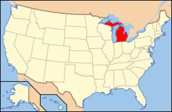
Översiktskarta | |
Michigans läge i USA | |
| Wikimedia Commons: Ferndale, Michigan | |
| Webbplats: http://www.ferndalemi.gov | |
| Redigera Wikidata | |
Ferndale är en ort i Oakland County i delstaten Michigan, USA.
Referenser
- ^ hämtat från: engelskspråkiga Wikipedia.[källa från Wikidata]
- ^ United States Census Bureau, 2010 U.S. Gazetteer Files, United States Census Bureau, 2010, läst: 9 juli 2020.[källa från Wikidata]
- ^ United States Census Bureau (red.), USA:s folkräkning 2020, läs online, läst: 1 januari 2022.[källa från Wikidata]
Media som används på denna webbplats
Författare/Upphovsman:
| This media | uploader |
|---|---|
| Original work | en:User:Wapcaplet |
Map of USA with Michigan highlighted
Författare/Upphovsman: Arkyan, Licens: CC BY-SA 3.0
This map shows the incorporated and unincorporated areas in Oakland County, Michigan, highlighting Ferndale in red. I created it in Inkscape using data from the US Census Bureau.
(c) Stanthejeep at the English Wikipedia, CC BY-SA 3.0
Downtown Ferndale, MI c. winter 2005


