Fars (provins)
| Fars (استان فارس) | |
| Ostan-e Fars | |
| Provins | |
Fars läge i Iran | |
| Land | |
|---|---|
| Huvudort | Shiraz |
| - koordinater | 29°36′38″N 52°31′28″Ö / 29.61056°N 52.52444°Ö |
| Area | 120 608 km²[1] |
| Folkmängd | 4 851 274 (2016)[2] |
| Befolkningstäthet | 40 invånare/km² |
| Geonames | 134766 |

Fars (persiska: فارس), eller Ostan-e Fars (استان فارس), även tidigare känt som "Farsistan" (فارسستان)[3][4][5][6][7], är en provins i södra Iran med 4 851 274 invånare (2016),[2] på en yta av 120 608 km² (2016).[1] Största stad och administrativ huvudort är Shiraz. Andra större städer är Jahrom och Marvdasht.
Regionens namn var på fornpersiska Pârsa och på persiska Pars (پارس). Det var härifrån som akemenidernas välde utbredde sig över västra Asien 550–330 f.Kr. och föranledde grekerna att kalla hela väldet för Persien och hela folket för perser. De beteckningarna var de förhärskande i västvärlden fram till 1935, då shahen begärde att man skulle övergå till landsbeteckningen Iran och folkbeteckningen iranier, som användes inom landet.
Administrativ indelning
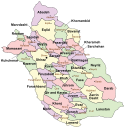
Provinsen Fars var vid folkräkningen 2016 indelad i 29 delprovinser (shahrestan),[2] i sin tur indelade på ytterligare administrativa nivåer.
Bildgalleri
- Ruiner av Tachara i Persepolis.
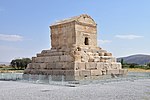
- Kyros den stores mausoleum i Pasargad.
- (c) Hadi Karimi, CC BY 3.0Ett rapsfält i Alamarvdasht.
Källor
- ^ [a b] Selected Findings of the 2016 National Population and Housing Census, Statistical Centre of Iran, augusti 2018. Läst 19 mars 2023.
- ^ [a b c] Census 2016: Population and Household of the Country by Province and Sub-province (Shahrestan), Statistical Center of Iran (SCI). Tillgänglig på Iran Data Portal. Läst 15 februari 2023.
- ^ https://www.britannica.com/place/Fars
- ^ https://www.google.no/books/edition/The_History_of_the_World_Comprising_a_Ge/ekoFAAAAYAAJ?hl=no&gbpv=1&dq=farsistan&pg=PA348&printsec=frontcover
- ^ https://www.google.no/books/edition/Lectures_on_ancient_history_from_the_ear/UmIBAAAAQAAJ?hl=no&gbpv=1&dq=farsistan&pg=PA94&printsec=frontcover
- ^ https://www.google.no/books/edition/Universal_geography_or_A_description_of/z2QDAAAAQAAJ?hl=no&gbpv=1&dq=farsistan&pg=PA307&printsec=frontcover
- ^ Sykes, Percy (1921). A History of Persia. London: Macmillan and Company. sid. 5. https://www.loc.gov/resource/gdclccn.24005676v1/?sp=43
Externa länkar
 Wikimedia Commons har media som rör Fars (provins).
| |||||
Media som används på denna webbplats
Flag of Iran. The tricolor flag was introduced in 1906, but after the Islamic Revolution of 1979 the Arabic words 'Allahu akbar' ('God is great'), written in the Kufic script of the Qur'an and repeated 22 times, were added to the red and green strips where they border the white central strip and in the middle is the emblem of Iran (which is a stylized Persian alphabet of the Arabic word Allah ("God")).
The official ISIRI standard (translation at FotW) gives two slightly different methods of construction for the flag: a compass-and-straightedge construction used for File:Flag of Iran (official).svg, and a "simplified" construction sheet with rational numbers used for this file.
Författare/Upphovsman: Carole Raddato, Licens: CC BY-SA 2.0
Ruins of the Tachara (Palace of Darius) in Persepolis, Persia (Persis/Fars), southwestern Iran.
Författare/Upphovsman: dynamosquito from France, Licens: CC BY-SA 2.0
The Tang-e Showgan gorge seen from the site of the ancient sasanian city of Bishapour, builded by Emperor Shapur Ist, 3rd century CE. 2 fortifications used to kep the access of the gorge, builded on each cliff boearding the natural path: the Khale-ye Dokhtar (Virgin's fortress) on the right cliff, and a little one localy known as Khale-ye Pessar (The young man's fortress). 6 sassanian rock reliefs are carved in the valley were flows the Rud-e Shapur (Shapur's river).
Taken at Bishapour, Viscinity of Kazerun, Fars province, Iran, April 2007.Författare/Upphovsman: Mostafameraji, Licens: CC BY-SA 4.0
The Karim Khan Castle (Persian: ارگ کریم خان Arg-e Karim Khan) is a citadel located in the downtown Shiraz, southern Iran. It was built as part of a complex during the Zand dynasty and is named after Karim Khan, and served as his living quarters. In shape it resembles a medieval fortress.
Författare/Upphovsman: Bernd81, Licens: CC BY-SA 4.0
This is a photo of a monument in Iran identified by the ID
(c) Hadi Karimi, CC BY 3.0
Canola field in Alamarvdasht مزرعه کلزا
Författare/Upphovsman: درفش کاویانی, Licens: CC BY 3.0
Ka'ba-ye Zartosht


