Estremadura
| Estremadura | |
| Historisk provins | |
 | |
| Land | |
|---|---|
Estremadura är en historisk provins i mellersta västra Portugal vid Atlanten.[1][2][3][4]
Under medeltiden omfattade Estremadura dagens distrikt runt Aveiro, Coimbra, Leiria, Lissabon, Santarém och Setúbal. Efter indelningsreformen 1936, blev Estremadura mindre och bestod då av dagens distrikt runt Leiria, Lissabon och Setúbal.[1]
Estremadura är bland annat känt för sin vinproduktion.[1]
Landskapet gränsar i väst till Atlanten, i norr till Beira Litoral, i öst till Ribatejo och Alto Alentejo och i söder till Baixo Alentejo.[5]
Viktiga städer
Bilder
 Óbidos
 Palmela
 Setúbal
 Estoril
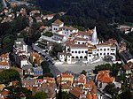 Sintra
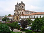 Alcobaça
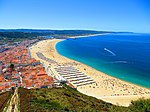 (c) Mister No, CC BY 3.0Nazaré
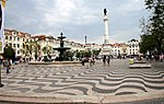 Lisboa
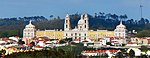 Mafra
Mafra Ericeira
 Sesimbra
 Bombarral
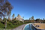 Loures
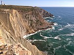 Cabo Espichel
Se även
Referenser
- ^ [a b c] ”Estremadura - Uppslagsverk – NE.se”. www.ne.se. https://www.ne.se/uppslagsverk/encyklopedi/l%C3%A5ng/estremadura. Läst 9 juli 2018. ”Estremadura, landskap i v. Portugal”
- ^ ”Estremadura” (på engelska). Encyclopaedia Britannica. https://www.britannica.com/place/Portugal. Läst 21 juni 2022. ”Estremadura, historical coastal province of central Portugal that contains Lisbon and the Tagus River estuary.”
- ^ Estremadura. Norstedts. 2007-2008. ISBN 9789113017136. ”Estremadura hist provins i Portugal”
- ^ ”Estremadura” (på portugisiska). Roteiro - Portugal Turístico. Lissabon: Círculo de Leitores. 1984. sid. 76-99. Depósito legal número: 4249/84
- ^ ”Estremadura” (på portugisiska). Infopédia. Porto Editora. https://www.infopedia.pt/apoio/artigos/$estremadura. Läst 21 juni 2022.
Externa länkar
 Wikimedia Commons har media som rör Estremadura.
| |||||||
Media som används på denna webbplats

Flag of Portugal.svg
Flag of Portugal, created by Columbano Bordalo Pinheiro (1857–1929), officially adopted by Portuguese government in June 30th 1911 (in use since about November 1910). Color shades matching the RGB values officially reccomended here. (PMS values should be used for direct ink or textile; CMYK for 4-color offset printing on paper; this is an image for screen display, RGB should be used.)
Flag of Portugal, created by Columbano Bordalo Pinheiro (1857–1929), officially adopted by Portuguese government in June 30th 1911 (in use since about November 1910). Color shades matching the RGB values officially reccomended here. (PMS values should be used for direct ink or textile; CMYK for 4-color offset printing on paper; this is an image for screen display, RGB should be used.)

Câmara Municipal de Palmela 09.jpg
Författare/Upphovsman: GualdimG, Licens: CC BY-SA 4.0
Câmara Municipal de Palmela
Författare/Upphovsman: GualdimG, Licens: CC BY-SA 4.0
Câmara Municipal de Palmela
.JPG)
Mafra - Palácio (cropped).JPG
Författare/Upphovsman: Paulo Juntas, Licens: CC BY-SA 2.5
Palácio Nacional de Mafra em Mafra
Författare/Upphovsman: Paulo Juntas, Licens: CC BY-SA 2.5
Palácio Nacional de Mafra em Mafra

Lissabon-Rossio-02-2011-gje.jpg
Författare/Upphovsman: Gerd Eichmann, Licens: CC BY-SA 4.0
Praça de Dom Pedro IV-Rossio at Lisbon in Portugal
Författare/Upphovsman: Gerd Eichmann, Licens: CC BY-SA 4.0
Praça de Dom Pedro IV-Rossio at Lisbon in Portugal
.jpg)

.jpg)
Cabo Espichel 20130728 (9410411539).jpg
Författare/Upphovsman: Pedro Veloso, Licens: CC BY 2.0
Cabo Espichel
Författare/Upphovsman: Pedro Veloso, Licens: CC BY 2.0
Cabo Espichel
.jpg)
Mosteiro de Alcobaça (Portugal).jpg
Författare/Upphovsman: Vitor Oliveira from Torres Vedras, PORTUGAL, Licens: CC BY 2.0
Panorama 360º - <a href="http://www.360portugal.com/Distritos.QTVR/Leiria.VR/Patrimonio/Alcobaca/index.html">www.360portugal.com/Distritos.QTVR/Leiria.VR/Patrimonio/A...</a>
Författare/Upphovsman: Vitor Oliveira from Torres Vedras, PORTUGAL, Licens: CC BY 2.0
Panorama 360º - <a href="http://www.360portugal.com/Distritos.QTVR/Leiria.VR/Patrimonio/Alcobaca/index.html">www.360portugal.com/Distritos.QTVR/Leiria.VR/Patrimonio/A...</a>

Setubal III.jpg
Författare/Upphovsman: Filipe Rocha,user:sacavem (pt) http://pt.wikipedia.org/wiki/Usu%C3%A1rio:Sacavem (pt:usuário:sacavem), Licens: CC BY-SA 3.0
Författare/Upphovsman: Filipe Rocha,user:sacavem (pt) http://pt.wikipedia.org/wiki/Usu%C3%A1rio:Sacavem (pt:usuário:sacavem), Licens: CC BY-SA 3.0
Setúbal is a city and a municipality in Portugal with a total area of 172.0 km² and a total population of 118,696 inhabitants in the municipality. The city proper has 89,303[1] inhabitants.
The municipality is composed of 8 parishes, and is located in the district of Setúbal..jpg)
Arredores da Columbeira - Portugal (8082685225).jpg
Författare/Upphovsman: Vitor Oliveira from Torres Vedras, PORTUGAL, Licens: CC BY-SA 2.0
<a href="http://loc.alize.us/#/flickr:8082685225" rel="nofollow">See where this picture was taken.</a> <a href="https://www.flickr.com/groups/geotagging/discuss/72157594165549916/">[?]</a>
Författare/Upphovsman: Vitor Oliveira from Torres Vedras, PORTUGAL, Licens: CC BY-SA 2.0
<a href="http://loc.alize.us/#/flickr:8082685225" rel="nofollow">See where this picture was taken.</a> <a href="https://www.flickr.com/groups/geotagging/discuss/72157594165549916/">[?]</a>
.jpg)
Parque da Cidade de Loures - Portugal (7136992813).jpg
Författare/Upphovsman: Vitor Oliveira from Torres Vedras, PORTUGAL, Licens: CC BY-SA 2.0
<a href="http://loc.alize.us/#/flickr:7136992813" rel="nofollow">See where this picture was taken.</a> <a href="https://www.flickr.com/groups/geotagging/discuss/72157594165549916/">[?]</a>
Författare/Upphovsman: Vitor Oliveira from Torres Vedras, PORTUGAL, Licens: CC BY-SA 2.0
<a href="http://loc.alize.us/#/flickr:7136992813" rel="nofollow">See where this picture was taken.</a> <a href="https://www.flickr.com/groups/geotagging/discuss/72157594165549916/">[?]</a>
.jpg)
.jpg)
Sesimbra - Portugal (7257864518).jpg
Författare/Upphovsman: Vitor Oliveira from Torres Vedras, PORTUGAL, Licens: CC BY-SA 2.0
<a href="http://loc.alize.us/#/flickr:7257864518" rel="nofollow">See where this picture was taken.</a> <a href="https://www.flickr.com/groups/geotagging/discuss/72157594165549916/">[?]</a>
Författare/Upphovsman: Vitor Oliveira from Torres Vedras, PORTUGAL, Licens: CC BY-SA 2.0
<a href="http://loc.alize.us/#/flickr:7257864518" rel="nofollow">See where this picture was taken.</a> <a href="https://www.flickr.com/groups/geotagging/discuss/72157594165549916/">[?]</a>


Sintra 2006.JPG
Sintra (Portugal)
Sintra (Portugal)