Estoril
| Estoril | |
| Stadsdel | |
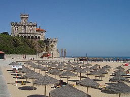
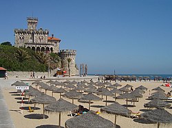
Praia do Tamariz | |
| Land | |
|---|---|
| Provins | Estremadura |
| Distrikt | Lissabon |
| Kommun | Cascais |
| Koordinater | 38°42′15″N 9°23′54″V / 38.70417°N 9.39833°V |
| Folkmängd | 26 397 |
| Geonames | 2268436 |
Estorils läge i Portugal. | |
Estoril är en ort och kommundel i Cascais kommun i Portugal, belägen vid Atlantkusten cirka 25 km väster om Lissabon. [1] Estoril har 26 397 invånare (2011) och är en billig och uppskattad semesterort med bland annat internationellt kasino och betydande turism både sommar och vinter. [2] [3]
Evenemang
- Festival de Jazz do Estoril
- Estoril Music Festival
- Estoril Open
- Estoril Film Festival
- Estoril Congress Center
- Portugal Moto GP
Referenser
- ^ ”Estoril” (på engelska). Encyclopaedia Britannica. https://www.britannica.com/place/Estoril. Läst 30 maj 2022.
- ^ ”Estoril”. Nationalencyklopedin. https://www.ne.se/uppslagsverk/encyklopedi/l%C3%A5ng/estoril. Läst 30 maj 2022.
- ^ ”Estoril” (på portugisiska). Infopédia. Porto Editora. https://www.infopedia.pt/apoio/artigos/$estoril?uri=toponimia/Estoril. Läst 30 maj 2022.
Se även
- Autódromo Fernanda Pires da Silva
- Casino Estoril
- Cascais
- Sintra
Media som används på denna webbplats
Flag of Portugal, created by Columbano Bordalo Pinheiro (1857–1929), officially adopted by Portuguese government in June 30th 1911 (in use since about November 1910). Color shades matching the RGB values officially reccomended here. (PMS values should be used for direct ink or textile; CMYK for 4-color offset printing on paper; this is an image for screen display, RGB should be used.)
Shiny red button/marker widget. Used to mark the location of something such as a tourist attraction.
Författare/Upphovsman: NordNordWest, Licens: CC BY-SA 3.0
Location map of Portugal


