Essoyes
| Essoyes | ||
| Kommun | ||
 | ||
| ||
| Land | ||
|---|---|---|
| Region | Grand Est | |
| Departement | ||
| Arrondissement | Troyes | |
| Kanton | Essoyes | |
| Koordinater | 48°4′N 4°32′Ö / 48.067°N 4.533°Ö | |
| Yta | 35,57 km²[1] | |
| Folkmängd | 711 ()[2] | |
| Befolkningstäthet | 20 invånare/km² | |
| Tidszon | CET (UTC+1) | |
| - sommartid | CEST (UTC+2) | |
| Postnummer | 10360 | |
| INSEE | 10141 | |
| Geonames | 6426396 | |
| OSM-karta | 3003821 | |
 Kommunens läge i regionen Grand Est i Frankrike. | ||
| Webbplats: http://www.essoyes.fr | ||

Essoyes är en kommun i departementet Aube i regionen Grand Est (tidigare regionen Champagne-Ardenne) i nordöstra Frankrike. Kommunen ligger i kantonen Essoyes som ligger i arrondissementet Troyes. År 2022 hade Essoyes 711 invånare.
Befolkningsutveckling
Antalet invånare i kommunen Essoyes
Referens: INSEE[3]
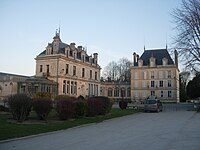
Galleri
 Rådhuset
 Kyrkan
 Slottet
Se även
Källor
- ^ Répertoire géographique des communes, Institut national de l'information géographique et forestière, läst: 26 oktober 2015.[källa från Wikidata]
- ^ Populations légales 2022, Institut National de la Statistique et des Études Économiques, 19 december 2024.[källa från Wikidata]
- ^ Chiffres clés - Évolution et structure de la population Arkiverad 5 juli 2012 hämtat från the Wayback Machine.
Media som används på denna webbplats


Författare/Upphovsman: Eric Gaba (Sting - fr:Sting), Licens: CC BY-SA 4.0
Blank physical map of metropolitan France for geo-location purpose.
Scale : 1:14 816 000 (accuracy : about 3,7 km) for the bathymetry. More maps of France, view → Commons Atlas of France.

Shiny red button/marker widget. Used to mark the location of something such as a tourist attraction.

Château d'Essoyes (Aube)
Författare/Upphovsman:
|
Map data (c) OpenStreetMap contributors, CC-BY-SA _French_municipality_map.svg) • Shape files infrastructure: railway, highways, water: all originally by OpenStreetMap contributors. Status december 2011 *note: shown commune boundaries are from OSM dump May 2012; at that time about 90% complete |
Map commune FR insee code 10141.png

Författare/Upphovsman: Chatsam, Licens: CC BY-SA 3.0
blason de la commune d'Essoyes, aube, france :tiercé en fasce : au 1) d’azur à l’oie d’argent, becquée de gueules sur un mont de sinople, au 2) losangé d’or et de sable, au 3) d’or aux trois pals de sable.


Författare/Upphovsman: Hg marigny, Licens: CC BY-SA 3.0
Lavoir d'Essoyes sur l'Ource