Enterprise, Alabama
| Enterprise | |
Läge i Alabama, USA | |
| Land | |
|---|---|
| Delstat | Alabama |
| County | Coffee County, Dale County |
| Höjdläge | 109 m ö.h. |
| Koordinater | 31°19′42″N 85°50′39″V / 31.32833°N 85.84417°V |
| Yta | 81,1 km² (2010)[1] |
| - land | 80,9 km² |
| - vatten | 0,2 km² |
| Folkmängd | 26 562 (2010)[2] |
| Befolkningstäthet | 328 invånare/km² |
| Styre | Kenneth W. Boswell |
| Tidszon | CST (UTC-6) |
| - sommartid | CDT (UTC-5) |
| ZIP-kod | 36330[3] |
| FIPS | 0124184 |
| Geonames | 4060791 |
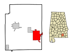
Ortens läge i Alabama | |
Alabamas läge i USA | |

Enterprise är en stad i den amerikanska delstaten Alabama med en yta av 80,3 km² och en befolkning, som uppgår till ungefär 21 000 invånare (2000). Av befolkningen är cirka 23 procent afroamerikanska.
Staden är belägen i den sydöstra delen av delstaten omkring 65 kilometer väster om gränsen till Georgia och ungefär 130 kilometer sydost om delstatens huvudstad Montgomery.
Fort Rucker gränsar till staden.
Referenser
- ^ ”2010 Census Gazetteer Files”. US Census Bureau. Arkiverad från originalet den 14 juli 2012. https://www.webcitation.org/699nOulzi?url=http://www.census.gov/geo/www/gazetteer/files/Gaz_places_national.txt. Läst 14 juli 2012.
- ^ ”Enterprise (city), Alabama” (på engelska). State & County Quickfacts. U.S. Census Bureau,. 29 juni 2012. Arkiverad från originalet den 9 juni 2012. https://www.webcitation.org/68Hwv2osB?url=http://quickfacts.census.gov/qfd/states/01/0124184.html. Läst 9 juni 2012.
- ^ ”2010 ZIP Code Tabulation Area (ZCTA) Relationship Files”. U.S. Census Bureau. 3 augusti 2010. Arkiverad från originalet den 25 augusti 2012. https://www.webcitation.org/6ABdwXxbq?url=http://www.census.gov/geo/www/2010census/zcta_rel/zcta_place_rel_10.txt. Läst 25 augusti 2012.
Externa länkar
 Wikimedia Commons har media som rör Enterprise.
| ||||||||||
Media som används på denna webbplats
Shiny red button/marker widget. Used to mark the location of something such as a tourist attraction.
Författare/Upphovsman: Huebi, Licens: CC BY 2.0
Map of USA with Alabama highlighted
Författare/Upphovsman: Alexrk2, Licens: CC BY 3.0
Den här Det karta skapades med GeoTools.
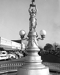
The Boll Weevil Monument in Enterprise, Alabama. "After the boll weevil destroyed (1910-15) the area's cotton, locals began diversified farming. In gratitude for the resulting prosperity, the city erected a monument to the boll weevil in 1919." [from The Columbia Encyclopedia, 3rd ed., s.v. Enterprise."] Series VII.1, Photographs, Box 7.1/3, file "II. Photographs--Boll Weevil Monument, Alabama," USDA History Collection, Special Collections, National Agricultural Library.
|
This is an image of a place or building that is listed on the National Register of Historic Places in the United States of America. Its reference number is 73000336. |
Författare/Upphovsman: Arkyan, Licens: CC BY-SA 3.0
This map shows the incorporated and unincorporated areas in Coffee County, Alabama, highlighting Enterprise in red. It was created with a custom script with US Census Bureau data and modified with Inkscape.


