Encinitas
| Encinitas | |
| city | |
Moonlight Beach i Encinitas. | |
| Land | |
|---|---|
| Delstat | Kalifornien |
| County | San Diego County |
| Koordinater | 33°3′2″N 117°15′49″V / 33.05056°N 117.26361°V |
| Yta | 51,8 km² (2010)[1] |
| - land | 48,7 km² |
| - vatten | 3,1 km² |
| Folkmängd | 60 400 (2011)[2] |
| Befolkningstäthet | 1 240 invånare/km² |
| Tidszon | PST (UTC-8) |
| - sommartid | PDT (UTC-7) |
| ZIP-kod | 92007, 92009, 92024, 92067, 92075, 92091[3] |
| FIPS | 0622678 |
| Geonames | 5346646 |
Ortens läge i Kalifornien | |
Kaliforniens läge i USA | |
Encinitas är en stad (city) i San Diego County, i delstaten Kalifornien, USA. Enligt United States Census Bureau har staden en folkmängd på 60 400 invånare (2011) och en landarea på 48,7 km².
Galleri
- Båthusen byggda på 20-talet räknas som historiska landmärken.
- Downtown Encinitas.
- The D Street overlook.
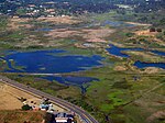
- San Elijo Lagoon.
Källor
- ^ ”2010 Census Gazetteer Files”. US Census Bureau. Arkiverad från originalet den 14 juli 2012. https://www.webcitation.org/699nOulzi?url=http://www.census.gov/geo/www/gazetteer/files/Gaz_places_national.txt. Läst 14 juli 2012.
- ^ ”Annual Estimates of the Resident Population for Incorporated Places: April 1, 2010 to July 1, 2011”. Arkiverad från originalet den 4 september 2012. https://www.webcitation.org/6AQvi6laS?url=http://www.census.gov/popest/data/cities/totals/2011/tables/SUB-EST2011-03-06.csv. Läst 4 september 2012.
- ^ ”2010 ZIP Code Tabulation Area (ZCTA) Relationship Files”. U.S. Census Bureau. 2 augusti 2010. Arkiverad från originalet den 25 augusti 2012. https://www.webcitation.org/6ABdwXxbq?url=http://www.census.gov/geo/www/2010census/zcta_rel/zcta_place_rel_10.txt. Läst 25 augusti 2012.
Externa länkar
- State & County QuickFacts, US Census Bureau.
 Wikimedia Commons har media som rör Encinitas.
| ||||||||||
Media som används på denna webbplats
Författare/Upphovsman: NordNordWest, Licens: CC BY 3.0
Location map of California, USA
Shiny red button/marker widget. Used to mark the location of something such as a tourist attraction.
Författare/Upphovsman: Huebi, Licens: CC BY 2.0
Map of USA with California highlighted
Flag of California. This version is designed to accurately depict the standard print of the bear as well as adhere to the official flag code regarding the size, position and proportion of the bear, the colors of the flag, and the position and size of the star.
Författare/Upphovsman: Philkon (Phil Konstantin), Licens: CC BY-SA 3.0
A photo of San Elijo Lagoon (San Diego County, California, USA) taken from a helicopter at approximately 1200 feet. This is looking eastward with Manchester Ave in the photo.
- Please acknowledge "Phil Konstantin" as the creator of this photograph.
Författare/Upphovsman: Invertzoo, Licens: CC BY-SA 3.0
Built in the late 1920s, the boathouses are historic landmarks in Encinitas
Författare/Upphovsman: Mikefairbanks, Licens: CC BY-SA 3.0
Downtown Encinitas, California, USA. Pictured is the Welcome Arch and the La Paloma Theater.
Författare/Upphovsman: Brovell, Licens: CC BY-SA 3.0
This picture was taken in Encinitas, California located on D Street. This is a sign which is a locator for the beach overlook and stairs down to the beach.
Författare/Upphovsman: Original uploader was Ohnoitsjamie at en.wikipedia, Licens: CC BY 2.0
Moonlight Beach park - Encinitas - San Diego County, California.


