Ely, Nevada
| Ely | |
| city | |
Ely från Ward Mountain. | |
| Land | |
|---|---|
| Delstat | Nevada |
| County | White Pine County |
| Höjdläge | 1 962 m ö.h. |
| Koordinater | 39°14′51″N 114°53′19″V / 39.24750°N 114.88861°V |
| Yta | 18,5 km² (2010) |
| - land | 18,5 km² |
| - vatten | 0,0 km² |
| Folkmängd | 4 255 (2010) |
| Befolkningstäthet | 230 invånare/km² |
| Tidszon | PST (UTC-8) |
| - sommartid | PDT (UTC-7) |
| ZIP-kod | 89301, 89315 |
| Riktnummer | 775 |
| FIPS | 3223500 |
| Geonames | 5503694 |
Ortens läge i Nevada | |
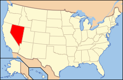
Nevadas läge i USA | |
| Webbplats: elynevada.net | |
Ely är administrativ huvudort i White Pine County i Nevada.[1] Ely är också den största staden i countyt.[2] Vid 2010 års folkräkning hade Ely 4 255 invånare.[3]
Kända personer från Ely
- Pat Nixon, USA:s första dam
Källor
- ^ Nevada County Map with County Seat Cities. Geology.com Geoscience News and Information. Läst 19 juli 2020.
- ^ Ely, NV. Map Quest. Läst 19 juli 2020.
- ^ 2010 Census Population of Ely, Nevada Arkiverad 19 juli 2020 hämtat från the Wayback Machine.. Census Viewer. Läst 19 juli 2020.
|
Media som används på denna webbplats
Shiny red button/marker widget. Used to mark the location of something such as a tourist attraction.
Författare/Upphovsman: NordNordWest, Licens: CC BY 3.0
Location map of Nevada, USA
Författare/Upphovsman: Famartin, Licens: CC BY-SA 3.0
View of downtown Ely, Nevada from the lower slopes of Ward Mountain.
Författare/Upphovsman: This version: uploader
Base versions this one is derived from: originally created by Wapcaplet, Licens: CC BY 2.0
Locator map of Nevada — in the Western United States.


