Ellsworth, Maine
| Ellsworth | |
| Stad (city) | |
| Uppkallad efter: Oliver Ellsworth[1] | |
| Land | |
|---|---|
| Delstat | |
| County | Hancock County |
| Höjdläge | 33 m ö.h. |
| Koordinater | 44°32′35″N 68°25′13″V / 44.54306°N 68.42028°V |
| Area | 243,25 km² (2010)[3] |
| Folkmängd | 8 399 (2020)[4] |
| Befolkningstäthet | 35 invånare/km² |
| Grundad | 1763[2] |
| Tidszon | EST (UTC-5) |
| - sommartid | EDT (UTC-4) |
| ZIP-kod | 04605 |
| Riktnummer | 207 |
| GNIS-kod | 565863 |
| Geonames | 4963692 |
Översiktskarta | |
Maines läge i USA | |
| Wikimedia Commons: Ellsworth, Maine | |
| Webbplats: http://www.cityofellsworthme.org/ | |
| Redigera Wikidata | |
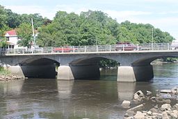
Ellsworth är en stad i Hancock County i delstaten Maine, USA, med 6 456 invånare (2000). Den har enligt United States Census Bureau en area på 243 km². Ellsworth är administrativ huvudort (county seat) i Hancock County.
Referenser
- ^ Henry Gannett, The Origin of Certain Place Names in the United States, andra utgåvan, Government Printing Office, 1905, s. 118, läs online, licens: public domain.[källa från Wikidata]
- ^ hämtat från: franskspråkiga Wikipedia.[källa från Wikidata]
- ^ United States Census Bureau, 2010 U.S. Gazetteer Files, United States Census Bureau, 2010, läst: 9 juli 2020.[källa från Wikidata]
- ^ United States Census Bureau (red.), USA:s folkräkning 2020, läs online, läst: 1 januari 2022.[källa från Wikidata]
| ||||||||||
Media som används på denna webbplats
Författare/Upphovsman: Billy Hathorn, Licens: CC BY-SA 3.0
I took photo of Union River in Ellsworth, ME, with Canon camera.
Map of the state of Maine with County Outlines, highlighting the city of Ellsworth.


