El Coral
| El Coral | |
| Kommun | |
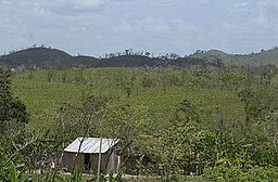
Landsbygden i El Coral | |
| Land | |
|---|---|
| Departement | Chontales |
| Koordinater | 11°54′57″N 84°39′01″V / 11.91583°N 84.650278°V |
| Centralort | El Coral |
| Area | 306 km² |
| Folkmängd | 7 909 (2012) |
| Befolkningstäthet | 26 invånare/km² |
| Grundad | 1997 |
| Tidszon | CST (UTC-6) |
| Geonames | 11002674 |
| Känd för[1] | Boskapsskötsel Gummi Nybyggare |
El Coral är en kommun (municipio) i Nicaragua med 7 909 invånare (2012). Den ligger i den centrala delen av landet i departementet Chontales. El Coral är en jordbruksbygd med omfattande boskapsskötsel.[2][3][4][1]
Geografi

El Coral gränsar till kommunerna Muelle de los Bueyes i norr, Nueva Guinea i öster, El Almendro i söder samt till Acoyapa och Villa Sandino i väster.[4]
Kommunens största ort är dess centralort El Coral, med 2 469 invånare (2005). Den ligger mitt i kommunen. Näst störst är Río Rama, i den södra delen av kommunen, med 1 070 invånare.[5]
Historia
El Coral hörde tidigare till kommunen Villa Sandino, men blev en egen kommun 1997.[2][6]
Källor
- ^ [a b] Juan Echánove och Joaquim Rabella, La guía de Nicaragua, 3a edicón, Editorial Hispamer, 2011.
- ^ [a b] ”Instituto Nicaragüense de Fomento Municipal, Ficha Municipal, El Coral”. Arkiverad från originalet den 16 juni 2009. https://web.archive.org/web/20090616205546/http://www.inifom.gob.ni/municipios/documentos/CHONTALES/el_coral.pdf. Läst 22 februari 2016.
- ^ Instituto Nacional de Información de Desarrollo, Población Total, estimada al 30 de Junio del año 2012. Arkiverad 2 maj 2013 hämtat från the Wayback Machine.
- ^ [a b] ”Zonu.com, Mapas Departamentos de Nicaragua”. Arkiverad från originalet den 26 november 2016. https://web.archive.org/web/20161126115038/http://www.zonu.com/mapas_nicaragua/Mapas_Mapa_Satelital_Foto_Imagen_Satelite_Nicaragua_2.htm#departamentos. Läst 22 februari 2016.
- ^ Instituto Nacional de Información de Desarrollo, Censo 2005. Arkiverad 19 augusti 2016 hämtat från the Wayback Machine.
- ^ Normas Jurídicas de Nicaragua, Ley creadora de los municipios de San Francisco de Cuapa y El Coral, La Gaceta No. 144 del 30 de Julio de 1997.
Media som används på denna webbplats
Författare/Upphovsman: Alexrk2, Licens: CC BY-SA 3.0
Physical Location map Nicaragua with Departamentos, Equirectangular projection, N/S stretching 100 %. Geographic limits of the map:
Shiny red button/marker widget. Used to mark the location of something such as a tourist attraction.
El Coral, Chontales


