East Sussex
| East Sussex | |||
| Ceremoniellt grevskap | |||
Kalkstensklippor vid Beachy Head nära Eastbourne. | |||
| |||
| Land | |||
|---|---|---|---|
| Riksdel | England | ||
| Region | Sydöstra England | ||
| Ingående distrikt | Hastings, Rother, Wealden, Eastbourne, Lewes, Brighton and Hove (enhetskommun) | ||
| Yta | 1 792 km²[1] | ||
| Folkmängd | 828 685 (2022)[2] | ||
| Befolkningstäthet | 462 invånare/km² | ||
| Tidszon | GMT (UTC+0) | ||
| - sommartid | BST (UTC+1) | ||
| Geonames | 11609033 | ||
| East Sussex | |
| Administrativt grevskap | |
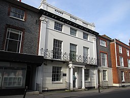
(c) Antiquary, CC BY-SA 4.0 | |
| Land | |
|---|---|
| Riksdel | England |
| Region | Sydöstra England |
| Ingående distrikt | Hastings, Rother, Wealden, Eastbourne, Lewes |
| Administrativ huvudort | Lewes |
| Yta | 1 709 km²[1] |
| Folkmängd | 550 720 (2022)[2] |
| Tidszon | GMT (UTC+0) |
| - sommartid | BST (UTC+1) |
| Geonames | 11609033 |
East Sussex är ett ceremoniellt och administrativt grevskap i sydöstra England. Den administrativa huvudorten är Lewes. East Sussex gränsar till Kent, Surrey och West Sussex.
Större orter är Bexhill-on-Sea, Brighton and Hove, Crowborough, Eastbourne, Hailsham, Hastings, Lewes, Newhaven, Peacehaven, Polegate, Seaford och Uckfield.
Flera populära så kallade badorter, till exempel Brighton och Eastbourne, är belägna vid East Sussex kust.
Administrativ indelning
Det traditionella grevskapet Sussex delades 1888 in i två administrativa grevskap, men förblev två ceremoniella grevskap. År 1974 blev de två enheterna även separata ceremoniella grevskap och området Mid Sussex överfördes från East Sussex till West Sussex.
Det administrativa grevskapet East Sussex omfattar hela det ceremoniella grevskapet East Sussex med undantag för det område som administreras av enhetskommunen Brighton and Hove. Det är indelat i fem distrikt.
| Nr | Distrikt / Enhetskommun | Administrativt grevskap | Distrikt i det ceremoniella grevskapet East Sussex |
|---|---|---|---|
| 1 | Brighton and Hove | Rött: Administrativa grevskapet East Sussex Gult: Enhetskommunen Brighton and Hove | |
| 2 | Lewes | East Sussex | |
| 3 | Wealden | ||
| 4 | Eastbourne | ||
| 5 | Rother | ||
| 6 | Hastings | ||
Landformer
I East Sussex finns:
- vattendragen River Brede och River Ouse
- insjön Bell Water
- kullarna Ditchling Beacon och Firle Beacon
- skogen St Helen's Wood
Källor
- ”East Sussex County, England, United Kingdom”. Encyclopædia Britannica. https://www.britannica.com/place/East-Sussex. Läst 12 oktober 2016.
Noter
- ^ [a b] ”Estimates of the population for the UK, England, Wales, Scotland, and Northern Ireland (Mid-2022)” (på engelska) (xls). Landyta, avrundad till hela km². Office for National Statistics. 26 mars 2024. https://www.ons.gov.uk/peoplepopulationandcommunity/populationandmigration/populationestimates/datasets/populationestimatesforukenglandandwalesscotlandandnorthernireland. Läst 25 juni 2024.
- ^ [a b] ”Estimates of the population for the UK, England, Wales, Scotland, and Northern Ireland (Mid-2022)” (på engelska) (xls). Office for National Statistics. 26 mars 2024. https://www.ons.gov.uk/peoplepopulationandcommunity/populationandmigration/populationestimates/datasets/populationestimatesforukenglandandwalesscotlandandnorthernireland. Läst 25 juni 2024.
Externa länkar
 Wikimedia Commons har media som rör East Sussex.
Media som används på denna webbplats
(c) Antiquary, CC BY-SA 4.0
166 High Street, Lewes, East Sussex, once the home of Gideon Mantell according to a plaque on the building, seen from the south.
Författare/Upphovsman: Sodacan, Licens: CC BY-SA 4.0
Arms of the East Sussex County Council (1975 - present): Gules between a fess wavy argent, six martlets three, two and one, and in chief a Saxon crown or.
Författare/Upphovsman:
- Beachy_Head_and_Lighthouse,_East_Sussex,_England_-_April_2010_crop_horizon_corrected.jpg: Diliff, Papa Lima Whiskey (edit)
- derivative work: Wolf im Wald
The cliffs of Beachy Head and the Lighthouse below, as viewed along the South Downs Way in East Sussex, England.
(c) Nilfanion, CC BY 3.0
Numbered districts of West Sussex ceremonial county. Derived from File:East Sussex UK district map (blank).svg, by Nilfanion.
Författare/Upphovsman: Nilfanion, Licens: CC BY-SA 3.0
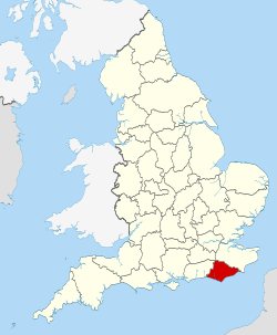
Location of the ceremonial county of East Sussex within England.


