East Palo Alto
| East Palo Alto | |||
| Stad (city) | |||
University Circle vid University Avenue och U.S. Route 101. | |||
| |||
| Land | |||
|---|---|---|---|
| Delstat | |||
| County | San Mateo County | ||
| Höjdläge | 6 m ö.h. | ||
| Koordinater | 37°28′12″N 122°7′48″V / 37.47000°N 122.13000°V | ||
| Area | 6,77 km² (2010)[1] | ||
| Folkmängd | 30 034 (2020)[2] | ||
| Befolkningstäthet | 4 439 invånare/km² | ||
| Tidszon | PST (UTC-8) | ||
| - sommartid | PDT (UTC-7) | ||
| ZIP-kod | 94303 | ||
| Riktnummer | 650 | ||
| GNIS-kod | 1658461 | ||
| Geonames | 5345032 | ||
Översiktskarta | |||
Kaliforniens läge i USA | |||
| Wikimedia Commons: East Palo Alto, California | |||
| Webbplats: http://www.ci.east-palo-alto.ca.us | |||
| Redigera Wikidata | |||
East Palo Alto (ofta förkortat EPA) är en stad i San Mateo County, Kalifornien, USA.
Bildgalleri
- Flygfoto över East Palo Alto, i riktning sydöst mot Mountain View, Kalifornien.
- East Palos kommunhus, där bland annat biblioteket finns.
Källor
- ^ United States Census 2010, läs online, läst: 9 juli 2020.[källa från Wikidata]
- ^ United States Census Bureau (red.), USA:s folkräkning 2020, läs online, läst: 1 januari 2022.[källa från Wikidata]
Externa länkar
 Wikimedia Commons har media som rör East Palo Alto.
| |||||||||||
Media som används på denna webbplats
Flag of California. This version is designed to accurately depict the standard print of the bear as well as adhere to the official flag code regarding the size, position and proportion of the bear, the colors of the flag, and the position and size of the star.
Författare/Upphovsman: Yngvadottir, Licens: CC BY-SA 4.0
East Palo Alto, California, municipal building, including city hall and library
Författare/Upphovsman: Huebi, Licens: CC BY 2.0
Map of USA with California highlighted
Författare/Upphovsman: David.Monniaux, Licens: CC BY-SA 3.0
From front to back: East Palo Alto, Palo Alto Airport of Santa Clara County, Moffett Federal Airfield
Författare/Upphovsman: LPS.1, Licens: CC0
University Circle in East Palo Alto, California
Författare/Upphovsman: Arkyan, Licens: CC BY-SA 3.0
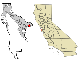
This map shows the incorporated and unincorporated areas in San Mateo County, California, highlighting East Palo Alto in red. It was created with a custom script with US Census Bureau data and modified with Inkscape.


