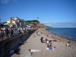
East Devon
| East Devon | |
| East Devon District | |
| Distrikt | |
| Land | |
|---|---|
| Riksdel | England |
| Region | Sydvästra England |
| Ceremoniellt grevskap | Devon |
| Administrativt grevskap | Devon |
| Koordinater | 50°46′N 3°12′V / 50.76°N 3.2°V |
| Administrativ huvudort | Honiton |
| Area | 814 km²[1] |
| Folkmängd | 154 500 (2022)[2] |
| Befolkningstäthet | 190 invånare/km² |
| Tidszon | UTC (UTC+0) |
| - sommartid | BST (UTC+1) |
| GSS-kod | E07000040 |
| Geonames | 7290674 |
Contains Ordnance Survey data © Crown copyright and database right, CC BY-SA 3.0 Läge i grevskapet Devon | |
| Webbplats: http://www.eastdevon.gov.uk/ | |
East Devon är ett distrikt (motsvarande kommun) i grevskapet Devon i England, Storbritannien. Distriktet har 154 500 invånare (2022)[2].
Större orter är Exmouth, Honiton och Sidmouth. Distriktet är indelat i 72 civil parishes.
Natur
Stora delar av East Devon utgörs av två Areas of Outstanding Natural Beauty, nämligen East Devon AONB och Blackdown Hills AONB. Hela East Devons kust är en del av världsarvet Jurassic Coast. Distriktet har 132 457 invånare (2011).[3]
Politik
Distriktets fullmäktige, East Devon District Council, är organiserat enligt "ledare och kabinett"-formen.
Artikelursprung
- Den här artikeln är helt eller delvis baserad på material från engelskspråkiga Wikipedia.
Källor
- ^ ”Estimates of the population for the UK, England, Wales, Scotland, and Northern Ireland (Mid-2022)” (på engelska) (xls). Landyta, avrundad till hela km². Office for National Statistics. 26 mars 2024. https://www.ons.gov.uk/peoplepopulationandcommunity/populationandmigration/populationestimates/datasets/populationestimatesforukenglandandwalesscotlandandnorthernireland. Läst 25 juni 2024.
- ^ [a b] ”Estimates of the population for the UK, England, Wales, Scotland, and Northern Ireland (Mid-2022)” (på engelska) (xls). Office for National Statistics. 26 mars 2024. https://www.ons.gov.uk/peoplepopulationandcommunity/populationandmigration/populationestimates/datasets/populationestimatesforukenglandandwalesscotlandandnorthernireland. Läst 25 juni 2024.
- ^ ONS. ”East Devon (Local Authority)”. Neighbourhood statistics. Arkiverad från originalet den 21 oktober 2016. https://web.archive.org/web/20161021040616/http://neighbourhood.statistics.gov.uk/dissemination/LeadKeyFigures.do?a=7&b=6275084&c=East+Devon&d=13&e=62&g=6415150&i=1001x1003x1032x1004&m=0&r=1&s=1474814243140&enc=1. Läst 25 september 2016.
Media som används på denna webbplats
Författare/Upphovsman: Herbythyme, Licens: CC BY-SA 4.0
The seafront at Sidmouth on the south Devon coast, UK. This is during the annual festival week.
Contains Ordnance Survey data © Crown copyright and database right, CC BY-SA 3.0
Map of Devon, UK with East Devon highlighted.
Equirectangular map projection on WGS 84 datum, with N/S stretched 150%


