Dutchess County
| Dutchess County | |
| County | |
(c) Daniel Case, CC BY-SA 3.0 | |
| Land | |
|---|---|
| Delstat | |
| Huvudort | Poughkeepsie |
| Största stad | Poughkeepsie |
| Area | 2 138 km² (2010)[1] |
| - land | 2 061 km² (96%) |
| - vatten | 77 km² (4%) |
| Folkmängd | 297 488 (2010)[2] |
| Befolkningstäthet | 144 invånare/km² |
| Grundat | 1683 |
| - uppkallat efter | Maria, hertiginna av York |
| Tidszon | EST (UTC-5) |
| - sommartid | EDT (UTC-4) |
| FIPS-kod | 36027 |
| Geonames | 5115580 |
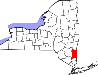
 Läge i delstaten New York. | |
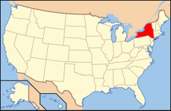
Delstatens läge i USA. | |
Dutchess County är ett administrativt område i delstaten New York, USA, med 297 488 invånare vid 2010 års folkräkning. Den administrativa huvudorten (county seat) är staden Poughkeepsie. Countyt är relativt tätbefolkat och tillhör norra delen av New Yorks storstadsregion.
Geografi
Enligt United States Census Bureau har countyt en total area på 2 138 km². 2 076 km² av den arean är land och 62 km² är vatten.
Angränsande countyn
- Columbia County, New York - nord
- Berkshire County, Massachusetts - nordost
- Litchfield County, Connecticut - öst
- Fairfield County, Connecticut - sydost
- Putnam County, New York - syd
- Orange County, New York - sydväst
- Ulster County, New York - väst
Källor
- ^ ”2010 Census U.S. Gazetteer Files for Counties”. U.S. Census Bureau. Arkiverad från originalet den 5 juli 2012. https://www.webcitation.org/68vYLbou5?url=http://www.census.gov/geo/www/gazetteer/files/Gaz_counties_national.txt. Läst 5 juli 2012.
- ^ ”State & County QuickFacts, Dutchess County, New York” (på engelska). U.S. Census Bureau. Arkiverad från originalet den 9 juli 2011. https://www.webcitation.org/603cmxYX8?url=http://quickfacts.census.gov/qfd/states/36/36027.html. Läst 6 juli 2011.
| |||||||||||||
|
Media som används på denna webbplats
Författare/Upphovsman: Huebi, Licens: CC BY 2.0
Map of USA with New York highlighted
This is a locator map showing Dutchess County in New York. For more information, see Commons:United States county locator maps.
(c) Daniel Case, CC BY-SA 3.0
Dutchess County Courthouse, Poughkeepsie, NY, USA
|
This is an image of a place or building that is listed on the National Register of Historic Places in the United States of America. Its reference number is 82001130. |
| Objektposition | | Se denna och andra närliggande bilder på: OpenStreetMap |
|---|


