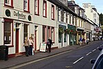
Dunkeld
| Dunkeld | |
| Dùn Chailleann, Dunkeld and Birnam | |
| Ort | |
(c) Jonathan Billinger, CC BY-SA 2.0 Torg i Dunkeld. | |
| Land | |
|---|---|
| Riksdel | Skottland |
| Enhetskommun | Perth and Kinross |
| Koordinater | 56°33′52″N 3°35′6″V / 56.56444°N 3.58500°V |
| Area | 0,80 km²[1] |
| Folkmängd | 1 320 (30 juni 2012)[1] |
| Befolkningstäthet | 1 650 inv./km² |
| Tidszon | GMT (UTC+0) |
| Postnummerområde | PH8 |
| Geonames | 2650716 |
Dunkeld (efter Dùn Chailleann på skotsk gaeliska) är en liten ort vid floden Tay i Skottland, cirka 25 kilometer norr om Perth i kommunen Perth and Kinross. Dunkeld är idag sammanväxt med Birnam, och orten (Dunkeld and Birnam) har cirka 1 300 invånare.
Bildgalleri
- (c) Gordon Hatton, CC BY-SA 2.0
Stadsvy från bron över Tay.
- (c) PAUL FARMER, CC BY-SA 2.0
Domkyrkoruinen
- (c) Jonathan Billinger, CC BY-SA 2.0
Bron över Tay.
Referenser
- Den här artikeln är helt eller delvis baserad på material från engelskspråkiga Wikipedia, Dunkeld, 17 oktober 2011.
Noter
- ^ [a b] General Register Office for Scotland; Population Densities of Localities, mid-2012 (excelfil) Arkiverad 3 september 2014 hämtat från the Wayback Machine. Läst 20 september 2014.
Media som används på denna webbplats
Författare/Upphovsman: Alexrk2, Licens: CC BY-SA 3.0
Location map of the United Kingdom
Shiny red button/marker widget. Used to mark the location of something such as a tourist attraction.
(c) Gordon Hatton, CC BY-SA 2.0
Dunkeld from the bridge The west side of Dunkeld village with the tower of the cathedral showing between the trees.
Författare/Upphovsman: Mogens Engelund, Licens: CC BY-SA 3.0
The mainstreet in Dunkeld, an important place in Scottish history
(c) Jonathan Billinger, CC BY-SA 2.0
Dunkeld Market Place and Fountain A fine small town in the Perthshire Highlands.
(c) PAUL FARMER, CC BY-SA 2.0
The Nave at Dunkeld Cathedral
(c) Jonathan Billinger, CC BY-SA 2.0
River Tay and bridge at Dunkeld A beautifully proportioned bridge at the crossing point of the river in its wooded gorge.
(c) Eric Gaba, NordNordWest, Uwe Dedering, CC BY-SA 3.0
Location map of Scotland, United Kingdom


