Dreux
| Dreux | ||
| Kommun | ||
 | ||
| ||
| Land | ||
|---|---|---|
| Region | Centre-Val de Loire | |
| Departement | ||
| Arrondissement | Dreux | |
| Kanton | chef-lieu för 3 kantoner | |
| Koordinater | 48°44′N 1°22′Ö / 48.733°N 1.367°Ö | |
| Yta | 24,27 km²[1] | |
| Folkmängd | 30 879 ()[2] | |
| Befolkningstäthet | 1 272 invånare/km² | |
| Borgmästare | Pierre-Frédéric Billet | |
| Tidszon | CET (UTC+1) | |
| - sommartid | CEST (UTC+2) | |
| Postnummer | 28100 | |
| INSEE | 28134 | |
| Geonames | 3020810 | |
| OSM-karta | 70807 | |
 Kommunens läge i regionen Centre-Val de Loire i Frankrike | ||
| Webbplats: http://www.dreux.com | ||

Dreux är en kommun i departementet Eure-et-Loir i regionen Centre-Val de Loire, väster om Paris. Kommunen är chef-lieu för 3 kantoner och för arrondissementet Dreux. År 2021 hade Dreux 30 879 invånare.
Befolkningsutveckling
Antalet invånare i kommunen Dreux
Referens:INSEE[3]
Galleri


 Museet
 Residensbyggnaden
Se även
Källor
- ^ Répertoire géographique des communes, Institut national de l'information géographique et forestière, läst: 26 oktober 2015.[källa från Wikidata]
- ^ Populations légales 2021, Institut National de la Statistique et des Études Économiques, 28 december 2023.[källa från Wikidata]
- ^ Chiffres clés - Évolution et structure de la population Arkiverad 5 juli 2012 hämtat från the Wayback Machine.
Media som används på denna webbplats


Shiny red button/marker widget. Used to mark the location of something such as a tourist attraction.
.svg)

Författare/Upphovsman: fr:Olivier2000, Licens: CC BY-SA 1.0
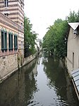
The Blaise, a tributary of the Eure in Dreux

Författare/Upphovsman: fr:Olivier2000, Licens: CC BY-SA 1.0
The Grand Rue - Maurice Violette in Dreux (Eure and Loir). In the background, the Chapel Saint-Louis
.jpg)

Författare/Upphovsman:
|
Map data (c) OpenStreetMap contributors, CC-BY-SA _French_municipality_map.svg) • Shape files infrastructure: railway, highways, water: all originally by OpenStreetMap contributors. Status december 2011 *note: shown commune boundaries are from OSM dump May 2012; at that time about 90% complete |
Map commune FR insee code 28134.png
Författare/Upphovsman: fr:User:Olivier2000, Licens: CC BY-SA 1.0
View at Dreux (Eure and Loir).

Författare/Upphovsman: fr:User:Olivier2000, Licens: CC BY-SA 1.0
Train station at Dreux

Författare/Upphovsman: Eric Gaba (Sting - fr:Sting), Licens: CC BY-SA 4.0
Blank physical map of metropolitan France for geo-location purpose.
Scale : 1:14 816 000 (accuracy : about 3,7 km) for the bathymetry. More maps of France, view → Commons Atlas of France.

Författare/Upphovsman: fr:User:Olivier2000, Licens: CC BY-SA 1.0
Marcel-Dessal municipal museum at Dreux

Författare/Upphovsman: unknown, Licens: CC BY-SA 1.0
Old houses with timber frames - Grand Rue of Dreux